Rouen
kota di Prancis
Rouen (pengucapan bahasa Prancis: [ʁwɑ̃]), merupakan kota yang terletak di Prancis bagian utara. Penduduknya berjumlah 105.000 jiwa (2005). Di sini juga adalah tempat di mana Jeanne d'Arc meninggal.
Rouen | |
|---|---|
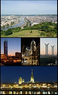
 Top:View of Downtown Rouen and Seine River from Bois Bagneres Hill, Middle left:Twilightview of Archives department of Seine Maritime building, Center:Nightview of Gros-Horloge, Middle right:Gustave-Flaobert Bridge, Bottom:Nightview of Rouen Norte-Dame Cathedral and Seine River | |
| Koordinat: 49°26′28″N 1°05′47″E / 49.4412°N 1.0963°E | |
| Negara | Prancis |
| Region | Normandia |
| Departemen | Seine-Maritime |
| Arondisemen | Rouen |
| Antarkomune | CREA |
| Pemerintahan | |
| • Wali kota (2008–2014) | Yvon Robert (PS) |
| Luas | |
| • Luas perkotaan (2017) | 461,1 km2 (1,780 sq mi) |
| • Luas metropolitan (2017) | 2.366,4 km2 (9,137 sq mi) |
| • Land1 | 21,38 km2 (825 sq mi) |
| • Peringkat | 37th in France |
| • Perkotaan (2017) | 467.575 |
| • Kepadatan perkotaan | 100/km2 (260/sq mi) |
| • Metropolitan (2017) | 666.035 |
| • Kepadatan metropolitan | 28/km2 (73/sq mi) |
| • Populasi2 | 114.187 |
| • Kepadatan Populasi2 | 53/km2 (140/sq mi) |
| Zona waktu | CET (UTC +1) |
| Kode INSEE/pos | 76540 / |
| Situs web | www.rouen.fr |
| 1 Data Pendaftaran Tanah Prancis, tak termasuk danau, kolam, gletser > 1 km² (0.386 mi² atau 247 ekar) dan muara sungai. 2 Population sans doubles comptes: penghitungan tunggal penduduk di komune lain (e.g. mahasiswa dan personil militer). | |


