Berkas:Zalzala Jazeera 2013 Gwadar.jpg
Tak tersedia resolusi yang lebih tinggi.
Zalzala_Jazeera_2013_Gwadar.jpg (720 × 480 piksel, ukuran berkas: 94 KB, tipe MIME: image/jpeg)
Ringkasan
| Deskripsi |
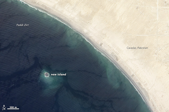
English: Zalzala Jazeera (Earthquake Island) appears near the center of this image of the bay west of Gwadar, Pakistan.
On September 26, 2013, the Advanced Land Imager (ALI) on NASA’s Earth Observing-1 (EO-1) satellite captured the top image of that new island, which sits roughly one kilometer (0.6 miles) offshore. Likely a “mud volcano,” the island rose from the seafloor near Gwadar on September 24, shortly after the earthquake struck about 380 kilometers (230 miles) inland. File:Gwadar satellite view.jpg, acquired by the Operational Land Imager on the Landsat 8 satellite, shows the same area on April 17, 2013. In the satellite images, lighter shades of green and tan in the water reveal shallow seafloor or suspended sediment. The water depth around the new island is roughly 15 to 20 meters, according to marine geologist Asif Inam of Pakistan’s National Institute of Oceanography. “The floor in that area is generally flat, but the gradient in this area changes quite abruptly,” Inam said. The top image from ALI is also clear enough to show the parallel ripples of waves marching toward the shore. |
| Tanggal | |
| Sumber | http://earthobservatory.nasa.gov/NaturalHazards/view.php?id=82146 |
| Pembuat | NASA |
| Versi lainnya |
 |
| Lokasi kamera | | Lihat gambar ini dan gambar di sekitarnya di: OpenStreetMap |
|---|
Lisensi
| Berkas ini berada dalam domain publik di Amerika Serikat karena semata-mata diciptakan oleh NASA. Kebijakan hak cipta NASA menyatakan bahwa "materi NASA tidak dilindungi oleh hak cipta kecuali dicatat". (Lihat Template:PD-USGov, Halaman kebijakan hak cipta NASA atau JPL Image Use Policy.) | ||
 |
Peringatan:
|
Riwayat berkas
Klik pada tanggal/waktu untuk melihat berkas ini pada saat tersebut.
| Tanggal/Waktu | Miniatur | Dimensi | Pengguna | Komentar | |
|---|---|---|---|---|---|
| terkini | 28 September 2013 01.33 | | 720 × 480 (94 KB) | Rehman | official nasa crop |
| 28 September 2013 01.18 |  | 459 × 486 (30 KB) | Ke4roh | User created page with UploadWizard |
Penggunaan berkas
Halaman berikut menggunakan berkas ini:
Penggunaan berkas global
Wiki lain berikut menggunakan berkas ini:
- Penggunaan pada ar.wikipedia.org
- Penggunaan pada as.wikipedia.org
- Penggunaan pada az.wikipedia.org
- Penggunaan pada bn.wikipedia.org
- Penggunaan pada ca.wikipedia.org
- Penggunaan pada cs.wikipedia.org
- Penggunaan pada el.wikipedia.org
- Penggunaan pada en.wikipedia.org
- Penggunaan pada es.wikipedia.org
- Penggunaan pada fa.wikipedia.org
- Penggunaan pada fi.wikipedia.org
- Penggunaan pada fr.wikipedia.org
- Penggunaan pada incubator.wikimedia.org
- Penggunaan pada it.wikipedia.org
- Penggunaan pada ja.wikipedia.org
- Penggunaan pada nl.wikipedia.org
- Penggunaan pada pnb.wikipedia.org
- Penggunaan pada ru.wikipedia.org
- Penggunaan pada scn.wikipedia.org
- Penggunaan pada sd.wikipedia.org
- Penggunaan pada simple.wikipedia.org
- Penggunaan pada sr.wikipedia.org
- Penggunaan pada tr.wikipedia.org
- Penggunaan pada uk.wikipedia.org
- Penggunaan pada ur.wikipedia.org
- Penggunaan pada vi.wikipedia.org
- Penggunaan pada www.wikidata.org