Berkas:Torpedoed Japanese destroyer Yamakaze sinking on 25 June 1942.jpg

Ukuran pratayang ini: 759 × 599 piksel. Resolusi lainnya: 304 × 240 piksel | 608 × 480 piksel | 973 × 768 piksel | 1.280 × 1.011 piksel | 2.560 × 2.021 piksel | 2.937 × 2.319 piksel.
Ukuran asli (2.937 × 2.319 piksel, ukuran berkas: 3,84 MB, tipe MIME: image/jpeg)
Ringkasan
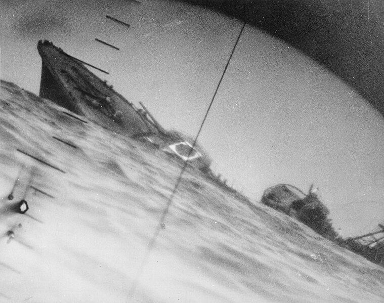
| Deskripsi | Sinking of the Japanese destroyer Yamakaze on 25 June 1942 approximately 110 km southeast of Yokosuku, Japan, photographed through the periscope of the U.S. Navy submarine USS Nautilus (SS-168). This position is given in The Official Chronology of the U.S. Navy in World War II by Robert Cressman. NH 111751 says 75 miles southwest of Yokahama Harbor. Yokahama is near Yokosuku. | |||
| Tanggal | ||||
| Sumber |
|
|||
| Pembuat | U.S. Navy | |||
| Versi lainnya | Official U.S. Navy photo NH 111751 from the U.S. Navy Naval History and Heritage Command |
| Lokasi kamera | | Lihat gambar ini dan gambar di sekitarnya di: OpenStreetMap |
|---|
|
Lisensi
This file is a work of a sailor or employee of the U.S. Navy, taken or made as part of that person's official duties. As a work of the U.S. federal government, it is in the public domain in the United States.
|
 | |
| Berkas ini telah diidentifikasi bebas dari pembatasan menurut hukum hak cipta termasuk semua hak terkait dan relevan. | ||
Riwayat berkas
Klik pada tanggal/waktu untuk melihat berkas ini pada saat tersebut.
| Tanggal/Waktu | Miniatur | Dimensi | Pengguna | Komentar | |
|---|---|---|---|---|---|
| terkini | 9 Oktober 2016 06.37 | | 2.937 × 2.319 (3,84 MB) | Cobatfor | new NHHC file |
| 21 Agustus 2007 20.55 |  | 2.985 × 2.048 (1,5 MB) | BrokenSphere | == Summary == {{Information |Description=Torpedoed Japanese destroyer photographed through periscope of U.S.S. Wahoo or U.S.S. Nautilus, June 1942. (Navy) Exact Date Shot Unknown NARA FILE #: 080-G-418331 WAR & CONFLICT BOOK #: 1315 |Source=High resolutio |
Penggunaan berkas
2 halaman berikut menggunakan berkas ini:
Penggunaan berkas global
Wiki lain berikut menggunakan berkas ini:
- Penggunaan pada ar.wikipedia.org
- Penggunaan pada azb.wikipedia.org
- Penggunaan pada bg.wikipedia.org
- Penggunaan pada bn.wikipedia.org
- Penggunaan pada ca.wikipedia.org
- Penggunaan pada cs.wikipedia.org
- Penggunaan pada en.wikipedia.org
- Periscope
- Pacific War
- USS Nautilus (SS-168)
- Salmon-class submarine
- Japanese destroyer Yamakaze (1936)
- Talk:Japanese destroyer Yamakaze (1936)
- Wikipedia:Featured pictures/History/World War II
- Allied submarines in the Pacific War
- List of shipwrecks in June 1942
- User talk:TomStar81/Archive 17
- Wikipedia:Featured pictures thumbs/51
- Wikipedia:Featured picture candidates/The death of the Imperial Japanese Destroyer Yamakaze as seen through the periscope of the submarine USS Nautilus (SS-168)
- Wikipedia:Featured picture candidates/April-2015
- Wikipedia:WikiProject Military history/News/May 2015/Articles
- Wikipedia:Wikipedia Signpost/2015-04-15/Featured content
- Wikipedia:Wikipedia Signpost/Single/2015-04-15
- List of maritime disasters in World War II
- Template:POTD/2018-06-25
- Wikipedia:Picture of the day/June 2018
- Wikipedia:Main Page history/2018 June 25
- Penggunaan pada es.wikipedia.org
- Penggunaan pada eu.wikipedia.org
- Penggunaan pada fa.wikipedia.org
- Penggunaan pada fi.wikipedia.org
- Penggunaan pada fr.wikipedia.org
- Penggunaan pada hu.wikipedia.org
- Penggunaan pada it.wikipedia.org
- Penggunaan pada ja.wikipedia.org
- Penggunaan pada ko.wikipedia.org
- Penggunaan pada nl.wikipedia.org
Lihat lebih banyak penggunaan global dari berkas ini.