Berkas:Pedra Branca Map.svg

Ukuran pratayang PNG ini dari berkas SVG ini: 800 × 487 piksel Resolusi lainnya: 320 × 195 piksel | 640 × 390 piksel | 1.024 × 624 piksel | 1.280 × 779 piksel | 2.560 × 1.559 piksel | 3.478 × 2.118 piksel.
Ukuran asli (Berkas SVG, secara nominal 3.478 × 2.118 piksel, besar berkas: 230 KB)
Ringkasan
| Deskripsi |
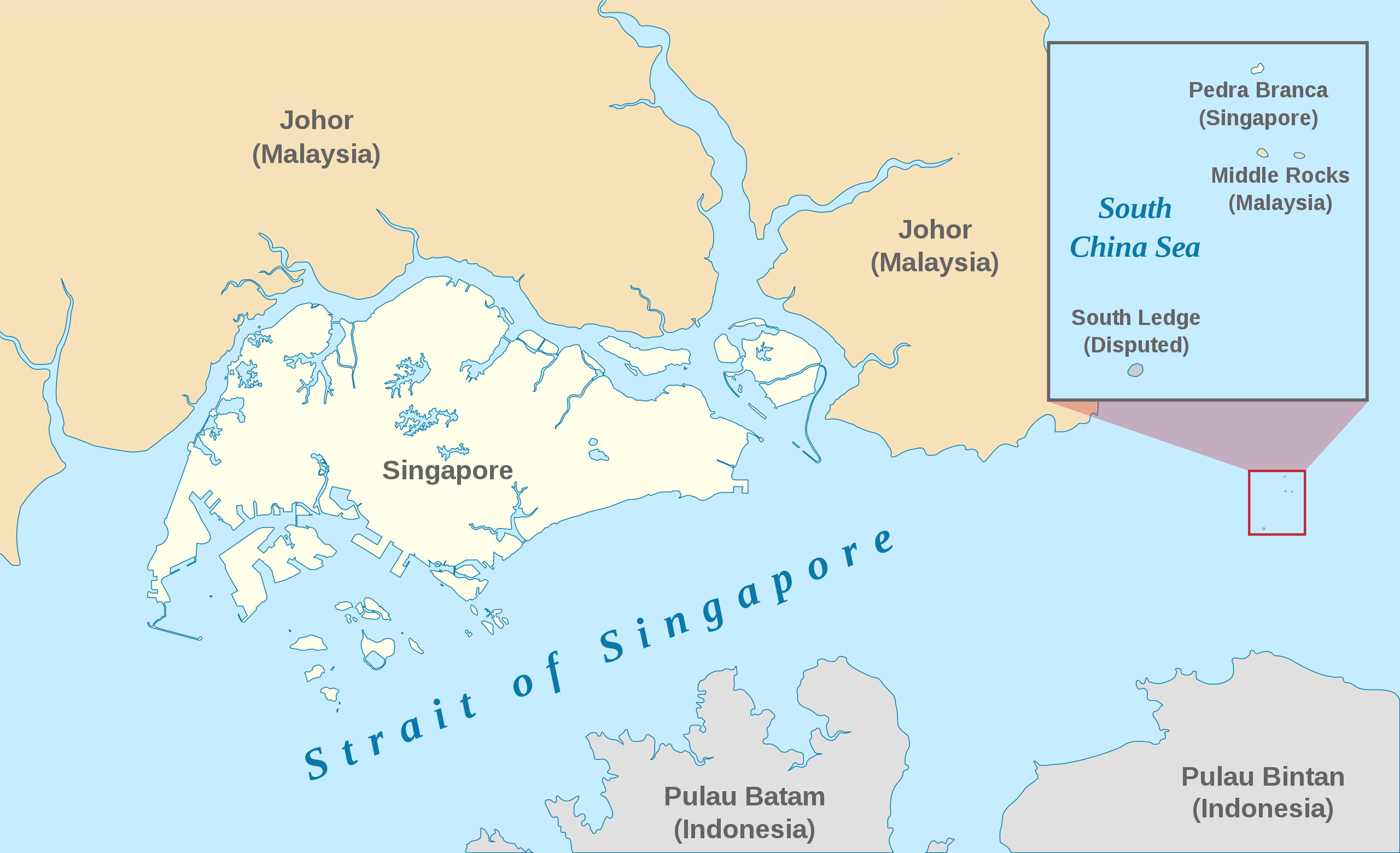
English: A map showing the approximate location of the island of Pedra Branca, which is under the sovereignty of Singapore, at the eastern end of the Singapore Strait where it meets the South China Sea. Near it are the maritime features Middle Rocks (under Malaysian sovereignty) and South Ledge, and the coasts of Johor, Malaysia, and Bintan, Indonesia. |
| Tanggal | |
| Sumber | Self-made, modified from Image:Singapore Outline.svg. |
| Pembuat | Jappalang. |
| Izin (Menggunakan kembali berkas ini) |
PD-Self. |
W3C-unspecified Gambar vektor ini dibuat menggunakan Inkscape .
Lisensi
| Saya, pemegang hak cipta karya ini, merilis karya ini ke domain umum. Lisensi ini berlaku di seluruh dunia. Di sejumlah negara, tindakan ini tidak memungkinkan secara sah; bila seperti itu: Saya memberikan siapa pun hak untuk menggunakan karya ini untuk tujuan apa pun, tanpa persyaratan apa pun, kecuali yang ditetapkan oleh hukum. |
Riwayat berkas
Klik pada tanggal/waktu untuk melihat berkas ini pada saat tersebut.
| Tanggal/Waktu | Miniatur | Dimensi | Pengguna | Komentar | |
|---|---|---|---|---|---|
| terkini | 13 Januari 2021 06.27 | | 3.478 × 2.118 (230 KB) | Seloloving | recoloured to Wikipedia map colour style |
| 9 Februari 2020 09.59 |  | 3.478 × 2.118 (219 KB) | *angys* | File uploaded using svgtranslate tool (https://tools.wmflabs.org/svgtranslate/). Added translation for zh. | |
| 22 Oktober 2017 14.36 |  | 3.478 × 2.118 (208 KB) | Seloloving | Fixed spelling error with "Enlargement" | |
| 22 Oktober 2017 14.34 |  | 3.478 × 2.118 (208 KB) | Seloloving | Recolored claimant states to a more neutral colour. Shifted the Insert Map further up and added note to clarify its actual location. Changed fonts and colours to align with Wikipedia Map guidelines. | |
| 24 Mei 2014 19.42 |  | 3.261 × 1.986 (194 KB) | Seloloving | Fixed text rendering. Fixed map. | |
| 4 Mei 2014 05.36 |  | 3.261 × 1.986 (276 KB) | Seloloving | Fixed Johor's shape. | |
| 4 Mei 2014 05.24 |  | 3.261 × 1.986 (274 KB) | Seloloving | Fixed font problems. | |
| 4 Mei 2014 05.20 |  | 3.261 × 1.986 (273 KB) | Seloloving | Fixed problems. | |
| 4 Mei 2014 05.12 |  | 3.261 × 1.986 (282 KB) | Seloloving | Fixed geography of the islands. | |
| 30 September 2008 04.05 |  | 3.261 × 1.986 (396 KB) | Jappalang | "South Lodge" corrected to "South Ledge" |
Penggunaan berkas
2 halaman berikut menggunakan berkas ini:
Penggunaan berkas global
Wiki lain berikut menggunakan berkas ini:
- Penggunaan pada de.wikipedia.org
- Penggunaan pada en.wikipedia.org
- Penggunaan pada es.wikipedia.org
- Penggunaan pada fr.wikipedia.org
- Penggunaan pada he.wikipedia.org
- Penggunaan pada it.wikipedia.org
- Penggunaan pada ja.wikipedia.org
- Penggunaan pada ko.wikipedia.org
- Penggunaan pada mdf.wikipedia.org
- Penggunaan pada ms.wikipedia.org
- Penggunaan pada pt.wikipedia.org
- Penggunaan pada ru.wikipedia.org
- Penggunaan pada ta.wikipedia.org
- Penggunaan pada th.wikipedia.org
- Penggunaan pada vi.wikipedia.org
- Penggunaan pada zh.wikipedia.org