Berkas:NPS acadia-map.jpg
Ukuran pratayang ini: 663 × 600 piksel. Resolusi lainnya: 265 × 240 piksel | 531 × 480 piksel | 849 × 768 piksel | 1.132 × 1.024 piksel | 2.264 × 2.048 piksel | 2.940 × 2.660 piksel.
Ukuran asli (2.940 × 2.660 piksel, ukuran berkas: 840 KB, tipe MIME: image/jpeg)
Ringkasan
| Deskripsi |
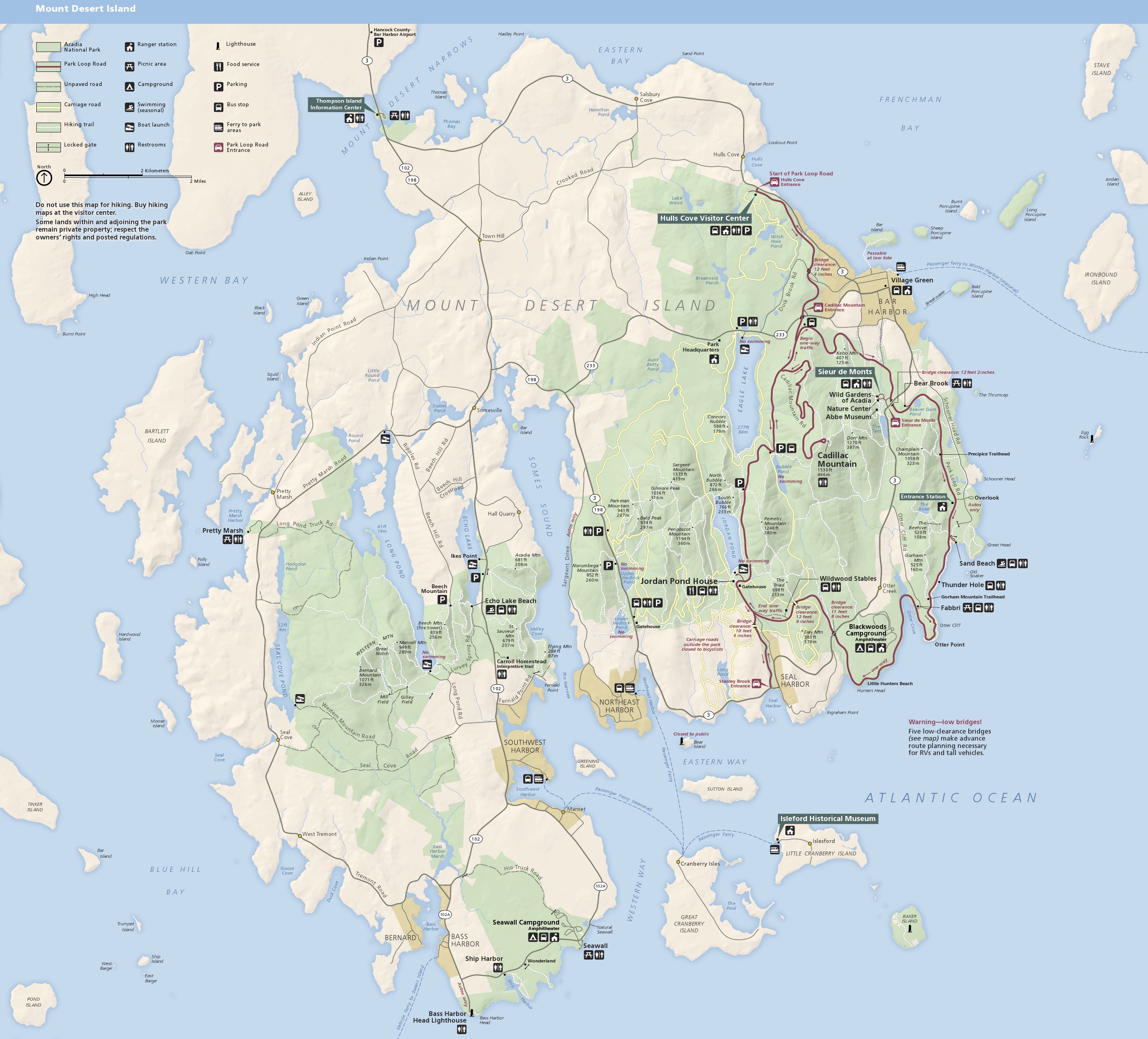
English: Main Acadia National Park map, showing the majority of the park located on Mount Desert Island near Bar Harbor. |
| Tanggal | |
| Sumber | U.S. National Park Service (http://npmaps.com/wp-content/uploads/acadia-map.jpg) |
| Pembuat | U.S. National Park Service, restoration/cleanup by Matt Holly |
| Versi lainnya |
 |
Lisensi
| This image or media file contains material based on a work of a National Park Service employee, created as part of that person's official duties. As a work of the U.S. federal government, such work is in the public domain in the United States. See the NPS website and NPS copyright policy for more information. |
Riwayat berkas
Klik pada tanggal/waktu untuk melihat berkas ini pada saat tersebut.
| Tanggal/Waktu | Miniatur | Dimensi | Pengguna | Komentar | |
|---|---|---|---|---|---|
| terkini | 11 Mei 2017 00.38 | | 2.940 × 2.660 (840 KB) | RKBot | =={{int:filedesc}}== {{Information |description= {{en|1=Main Acadia National Park map, showing the majority of the park located on Mount Desert Island near Bar Harbor.}} |date= 2013-10-27 |source= U.S. National Park Service (http://npmaps.com/wp-conten... |
Penggunaan berkas
Halaman berikut menggunakan berkas ini:
Penggunaan berkas global
Wiki lain berikut menggunakan berkas ini:
- Penggunaan pada de.wikipedia.org
- Penggunaan pada en.wikipedia.org
- Penggunaan pada it.wikipedia.org
- Penggunaan pada ru.wikipedia.org