Berkas:Himalayan Tectonic Summary.png
Ukuran pratayang ini: 800 × 519 piksel. Resolusi lainnya: 320 × 207 piksel | 640 × 415 piksel | 1.024 × 664 piksel | 1.280 × 830 piksel | 2.658 × 1.723 piksel.
Ukuran asli (2.658 × 1.723 piksel, ukuran berkas: 729 KB, tipe MIME: image/png)
Ringkasan
| Deskripsi |
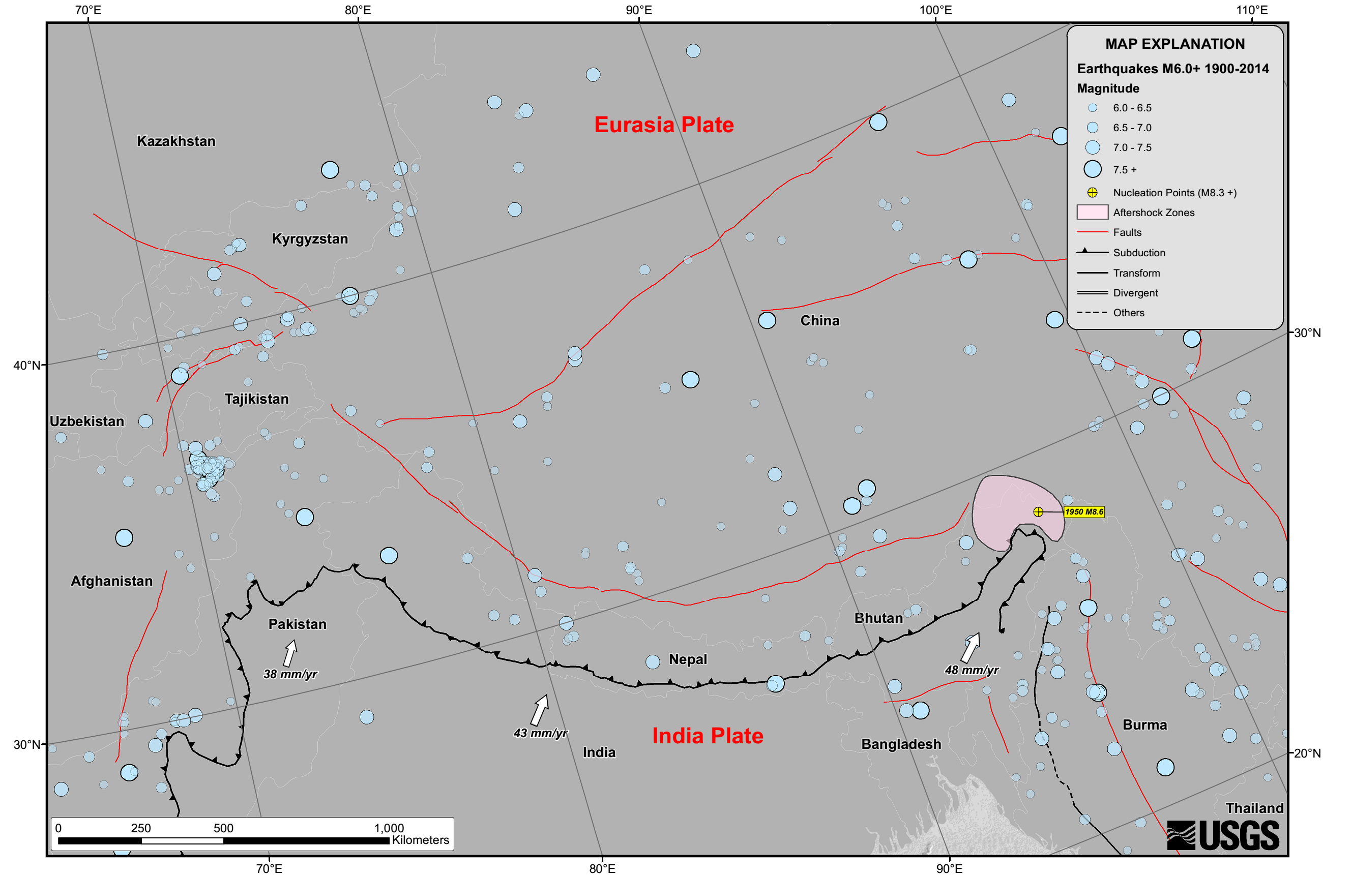
English: Seismicity in the Himalaya dominantly results from the continental collision of the India and Eurasia plates, which are converging at a relative rate of 40-50 mm/yr. Northward underthrusting of India beneath Eurasia generates numerous earthquakes and consequently makes this area one of the most seismically hazardous regions on Earth. The surface expression of the plate boundary is marked by the foothills of the north-south trending Sulaiman Range in the west, the Indo-Burmese Arc in the east and the east-west trending Himalaya Front in the north of India. |
| Tanggal | |
| Sumber | https://earthquake.usgs.gov/earthquakes/tectonic/images/himalaya_tsum.pdf |
| Pembuat | United States Geological Survey |
Lisensi
Gambar ini berada di domain umum di Amerika Serikat karena gamabar ini hanya mengandung bahan yang asli berasal dari Survei Geologi Amerika Serikat, sebuah badan Departemen Dalam Negeri Amerika Serikat. Untuk informasi lebih lanjut, lihat kebijakan hak cipta Survei Geologi Amerika Serikat resmi.
|
Riwayat berkas
Klik pada tanggal/waktu untuk melihat berkas ini pada saat tersebut.
| Tanggal/Waktu | Miniatur | Dimensi | Pengguna | Komentar | |
|---|---|---|---|---|---|
| terkini | 26 April 2015 10.53 | | 2.658 × 1.723 (729 KB) | Tatiraju.rishabh | User created page with UploadWizard |
Penggunaan berkas
Halaman berikut menggunakan berkas ini:
Penggunaan berkas global
Wiki lain berikut menggunakan berkas ini:
- Penggunaan pada af.wikipedia.org
- Penggunaan pada ar.wikipedia.org
- Penggunaan pada awa.wikipedia.org
- Penggunaan pada be.wikipedia.org
- Penggunaan pada en.wikipedia.org
- Penggunaan pada es.wikipedia.org
- Penggunaan pada hi.wikipedia.org
- Penggunaan pada nl.wikipedia.org
- Penggunaan pada pnb.wikipedia.org
- Penggunaan pada ru.wikipedia.org
- Penggunaan pada sl.wikipedia.org
- Penggunaan pada ta.wikipedia.org
- Penggunaan pada tg.wikipedia.org
- Penggunaan pada ur.wikipedia.org
- Penggunaan pada zh.wikipedia.org