Berkas:Gulf stream map.gif
Ukuran asli (700 × 612 piksel, ukuran berkas: 222 KB, tipe MIME: image/gif)
Ringkasan

|
Gambar ini dipindahkan ke Wikimedia Commons dari en.wikipedia menggunakan skrip bot. Semua informasi mengenai sumber masih ada. Hal ini membutuhkan peninjauan. Selain itu, mungkin ada kesalahan dalam salah satu bagian informasi; informasi pada gambar ini tidak boleh dianggap benar sampai dilakukan peninjauan; gambar tidak boleh digunakan sebelum dibuat koreksi yang diperlukan. Setelah peninjauan selesai, template ini harus dihapus. Untuk rincian tentang gambar ini, lihat di bawah. Periksa! |
| Deskripsi |
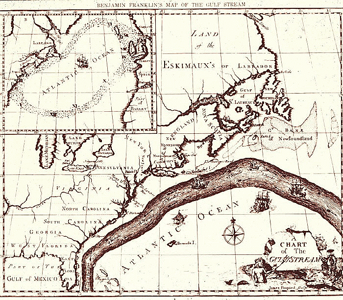
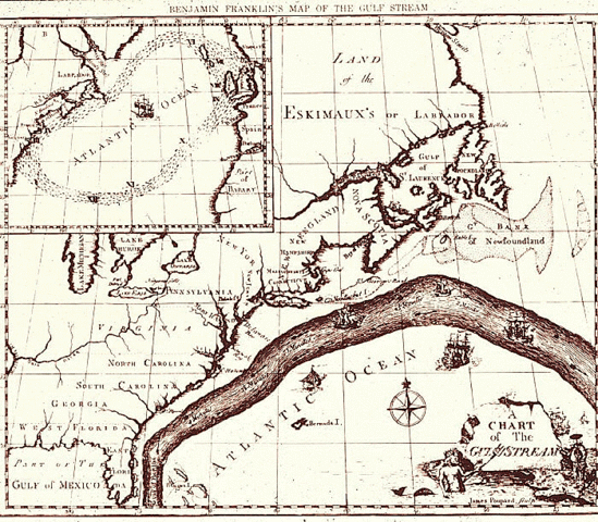
English: Map of the Gulf Stream by Benjamin Franklin. Courtesy of NOAA Photo Library. |
| Tanggal | 1769 - 1770 |
| Sumber | http://oceanexplorer.noaa.gov/library/readings/gulf/media/gulf_bf.html |
| Pembuat | Benjamin Franklin |
| Izin (Menggunakan kembali berkas ini) |
Public Domain |
Lisensi
|
This work is in the public domain in its country of origin and other countries and areas where the copyright term is the author's life plus 70 years or fewer.
| |
| Berkas ini telah diidentifikasi bebas dari pembatasan menurut hukum hak cipta termasuk semua hak terkait dan relevan. | |
Log pengunggahan asli
Dipindahkan dari en.wikipedia ke Commons oleh Sreejithk2000 menggunakan CommonsHelper.
- 2010-01-04 09:22 Zeamays 700×612× (227284 bytes) {{Information |Description = Map of the Gulf Stream by Benjamin Franklin. Courtesy of NOAA Photo Library. |Source = http://oceanexplorer.noaa.gov/library/readings/gulf/media/gulf_bf.html |Date = 1769-1770 |Author = Benjami
Riwayat berkas
Klik pada tanggal/waktu untuk melihat berkas ini pada saat tersebut.
| Tanggal/Waktu | Miniatur | Dimensi | Pengguna | Komentar | |
|---|---|---|---|---|---|
| terkini | 5 Juni 2010 06.23 | | 700 × 612 (222 KB) | File Upload Bot (Magnus Manske) | {{BotMoveToCommons|en.wikipedia|year={{subst:CURRENTYEAR}}|month={{subst:CURRENTMONTHNAME}}|day={{subst:CURRENTDAY}}}} {{Information |Description={{en|Map of the Gulf Stream by Benjamin Franklin. Courtesy of NOAA Photo Library.}} |Source=Transferred from |
Penggunaan berkas
Halaman berikut menggunakan berkas ini:
Penggunaan berkas global
Wiki lain berikut menggunakan berkas ini:
- Penggunaan pada da.wikipedia.org
- Penggunaan pada da.wikibooks.org
- Penggunaan pada en.wikipedia.org
- Penggunaan pada fr.wikipedia.org
- Penggunaan pada hy.wikipedia.org
- Penggunaan pada kn.wikipedia.org
- Penggunaan pada ko.wikipedia.org
- Penggunaan pada la.wikipedia.org
- Penggunaan pada mk.wikipedia.org
- Penggunaan pada oc.wikipedia.org
- Penggunaan pada si.wikipedia.org
- Penggunaan pada ta.wikipedia.org
- Penggunaan pada tl.wikipedia.org