Berkas:Breakwater break1 new(USGS).jpg

Ukuran asli (1.493 × 984 piksel, ukuran berkas: 812 KB, tipe MIME: image/jpeg)
.jpg)
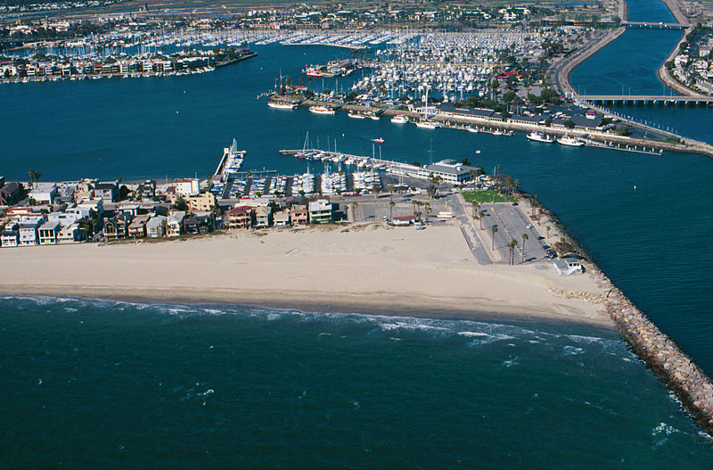
Breakwater.
Breakwaters create safe harbors but can also trap sediment moving along the coast. Long Beach Harbor, April, 1998
From: USGS
A more accurate description: The sand buildup shown is on the southeast end of the Long Beach Peninsula, with the jetty blocking the southward movement of sand being the west side of the entrance to Alamitos Bay. In the background, to the right of the center, is the Alamitos Bay Landing commercial area of the Long Beach Marina. To the far right in the back is the w:San Gabriel River. In the back top left is the sotheast end of w:Naples, a residential island in Alamitos Bay. The ocean shown in the foreground is the very southeast end of the Long Beach Outer Harbor.
Karya ini berada dalam domain publik di Amerika Serikat karena ini adalah karya yang disiapkan oleh seorang petugas atau karyawan dari Pemerintah Amerika Serikat sebagai bagian dari tugas resmi orang tersebut di bawah ketentuan Judul 17, Bab 1, Bagian 105 dari Kode Amerika Serikat. Lihat Hak cipta.
Catatan: Ini hanya berlaku untuk karya-karya asli dari Pemerintah Federal dan bukan karya setiap individual negara bagian, wilayah, persemakmuran, kabupaten, kota, atau subdivisi Amerika Serikat lainnya. Templat ini juga tidak berlaku untuk desain cap prangko yang diterbitkan oleh Layanan Pos Amerika Serikat sejak tahun 1978. (Lihat § 313.6(C)(1) of Compendium of U.S. Copyright Office Practices). Ini juga tidak berlaku untuk koin AS tertentu; lihat The US Mint Terms of Use.
|
 | |
| Berkas ini telah diidentifikasi bebas dari pembatasan menurut hukum hak cipta termasuk semua hak terkait dan relevan. | ||
Riwayat berkas
Klik pada tanggal/waktu untuk melihat berkas ini pada saat tersebut.
| Tanggal/Waktu | Miniatur | Dimensi | Pengguna | Komentar | |
|---|---|---|---|---|---|
| terkini | 10 Juni 2010 09.31 | | 1.493 × 984 (812 KB) | Quibik | cropped away 3 px from right edge and cloned the bottom edge a bit to remove black background |
| 10 Juni 2010 09.28 |  | 1.496 × 984 (814 KB) | Quibik | removed the timestamp | |
| 11 Desember 2009 18.05 |  | 1.496 × 984 (841 KB) | Foobaz | Larger version from http://coastal.er.usgs.gov/cgi-bin/response.pl?site=sc&loc=25 . | |
| 21 April 2005 09.02 |  | 295 × 193 (9 KB) | Feydey | Breakwater. Breakwaters create safe harbors but can also trap sediment moving along the coast. Long Beach Harbor, April, 1998 From: [http://walrus.wr.usgs.gov/cabrillo/playa/breakwater.html USGS] {{PD-USGov}} |
Penggunaan berkas
Halaman berikut menggunakan berkas ini:
Penggunaan berkas global
Wiki lain berikut menggunakan berkas ini:
- Penggunaan pada az.wikipedia.org
- Penggunaan pada da.wikipedia.org
- Penggunaan pada el.wikipedia.org
- Penggunaan pada en.wikipedia.org
- Penggunaan pada fi.wikipedia.org
- Penggunaan pada he.wikipedia.org
- Penggunaan pada kn.wikipedia.org
- Penggunaan pada ml.wikipedia.org
- Penggunaan pada sco.wikipedia.org
- Penggunaan pada simple.wikipedia.org
- Penggunaan pada vi.wikipedia.org
.jpg)