Berkas:Anglosphere Map.svg

Ukuran asli (Berkas SVG, secara nominal 2.754 × 1.398 piksel, besar berkas: 1,13 MB)
Ringkasan
| Deskripsi |
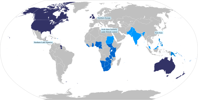
English: Map of the anglosphere.
Core Anglosphere
Middle Anglosphere
Outer sphere
Periphery |
| Tanggal | |
| Sumber |
Karya sendiri based on File:Anglosphere Geometry.svg Per James C. Bennett's "The Anglosphere challenge", which is one of the main sources for the very concept of the Anglosphere, as described by Browning, Christopher S. and Tonra, Ben (2010) "Beyond the West and towards the Anglosphere?" In: Browning, Christopher S. and Lehti, Marko, (eds.) The struggle for the West : a divided and contested legacy. Abingdon, Oxon ; New York: Routledge, pp. 161-181. ISBN 9780415476836: https://www.academia.edu/341929/Beyond_the_West_and_Towards_the_Anglosphere "In this respect he posits the existence of a series of concentric spheres marked according tohow far each shares core Anglosphere characteristics. At the core are the central nodes of the US and Britain surrounded by English-speaking Canada, Ireland,Australia, New Zealand and the English-speaking Caribbean. The middle sphere comprises states where English is one of several official languages, but where the primary connections to the outside world are in English. This includes English-speakers in South Africa (but not Afrikaans), Zimbabwe, the non-Islamic, non-Indian former British colonies in Africa, the South Pacific, and parts of Asia. The outer sphere comprises English-using states of other civilisations and might include India, Pakistan, the Arab states formerly under British control and Britain‘s former Islamic colonies. Finally, Bennett posits a peripheral sphere of states where English is widely used but is not an official governmental language. These include Northern Europe,East Asia and northern Latin America (Bennett 2004b: 80-1). What stands out here, of course, is the omission of continental Western Europe and the implication that the cultural differences between Latin and Germanic Europe (traditionally core components of the West) and the Anglosphere are greater than those between the inner core of the Anglosphere and those of its outer and peripheral spheres." |
| Pembuat | DimensionalFusion |
Lisensi
- Anda diizinkan:
- untuk berbagi – untuk menyalin, mendistribusikan dan memindahkan karya ini
- untuk menggubah – untuk mengadaptasi karya ini
- Berdasarkan ketentuan berikut:
- atribusi – Anda harus mencantumkan atribusi yang sesuai, memberikan pranala ke lisensi, dan memberi tahu bila ada perubahan. Anda dapat melakukannya melalui cara yang Anda inginkan, namun tidak menyatakan bahwa pemberi lisensi mendukung Anda atau penggunaan Anda.
- berbagi serupa – Apabila Anda menggubah, mengubah, atau membuat turunan dari materi ini, Anda harus menyebarluaskan kontribusi Anda di bawah lisensi yang sama seperti lisensi pada materi asli.
Riwayat berkas
Klik pada tanggal/waktu untuk melihat berkas ini pada saat tersebut.
| Tanggal/Waktu | Miniatur | Dimensi | Pengguna | Komentar | |
|---|---|---|---|---|---|
| terkini | 5 Mei 2022 18.35 | | 2.754 × 1.398 (1,13 MB) | DimensionalFusion | Updated labels for Peripheral |
| 3 Mei 2022 13.45 |  | 2.754 × 1.398 (1,12 MB) | DimensionalFusion | Uploaded while editing "Anglosphere" on en.wikipedia.org |
Penggunaan berkas
Halaman berikut menggunakan berkas ini:
Penggunaan berkas global
Wiki lain berikut menggunakan berkas ini:
- Penggunaan pada en.wikipedia.org
- Penggunaan pada fr.wiktionary.org
- Penggunaan pada uk.wikipedia.org
- Penggunaan pada zh-yue.wikipedia.org