Berkas:1570 Ortelius Map of Asia (first edition) - Geographicus - AsiaeNovaDescriptio-ortelius.jpg

Ukuran pratayang ini: 791 × 600 piksel. Resolusi lainnya: 317 × 240 piksel | 633 × 480 piksel | 1.013 × 768 piksel | 1.280 × 970 piksel | 2.560 × 1.941 piksel | 5.000 × 3.791 piksel.
Ukuran asli (5.000 × 3.791 piksel, ukuran berkas: 8,16 MB, tipe MIME: image/jpeg)
Ringkasan
| Abraham Ortelius: Asiae Nova Descriptio
( |
||||||||||||||||||||||||
|---|---|---|---|---|---|---|---|---|---|---|---|---|---|---|---|---|---|---|---|---|---|---|---|---|
| Seniman/Pembuat |
|
|||||||||||||||||||||||
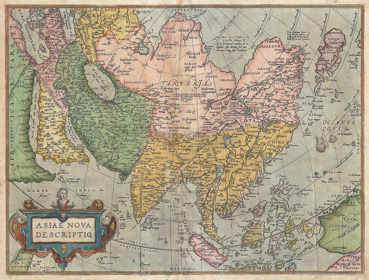
| Judul |
Asiae Nova Descriptio |
|||||||||||||||||||||||
| Deskripsi |
English: A scarce and stunning first edition example of Abraham Ortelius’ important 1572 map of Asia. Covers from Europe and Africa eastward to include all of Asia, the East Indies, Japan, and parts of New Guinea and Australia. From west to east, this map offers numerous elements worthy of further study. The Caspian Sea, according to the convention of the time, is presented on an east-west rather than north-south axis. Arabia is projected in a distended form. Further east in western China, Cayamay lacus is depicted. This mythical body of water was postulated by Ortelius to be the source great rivers of Southeast Asia. Indeed, Ortelius crisscrosses East Asia with a vast network of waterways advocating his belief that a water route existed through China to the North Sea and hence, via the Northeast Passage, to Europe. Still further east Japan appears in a distorted top heavy projection that resembles a tadpole. To the south Luzon is absent from the Philippine Islands. In the extreme southeast portion of the map Australia appears as “Terrae Incognitae Australis”. East of China, two sailing ships ply the waters of the Pacific. A large decorative title cartouche adorns the lower left hand quadrant. Ortelius based this map on his own wall map of 1567. This map was issued as page 3 in the 1872-73 German language edition of Ortelius’s Theatrum Orbis Terrarum and corresponds to Van den Broecke’s Ort 6 classification, predating the more common Ort 7 map of Asia that appeared in 1574. |
|||||||||||||||||||||||
| Tanggal | 1572 (undated) | |||||||||||||||||||||||
| Ukuran | Tinggi: 15 in (38,1 cm); lebar: 20 in (50,8 cm) | |||||||||||||||||||||||
| Kode inventaris |
Geographicus link: AsiaeNovaDescriptio-ortelius-1570 |
|||||||||||||||||||||||
| Sumber/Fotografer |
Ortelius, A., Theatrum Orbis Terrarum, (1572 German language edition)
|
|||||||||||||||||||||||
| Izin (Menggunakan kembali berkas ini) |
|
|||||||||||||||||||||||

_-_Geographicus_-_AsiaeNovaDescriptio-ortelius.jpg)
Riwayat berkas
Klik pada tanggal/waktu untuk melihat berkas ini pada saat tersebut.
| Tanggal/Waktu | Miniatur | Dimensi | Pengguna | Komentar | |
|---|---|---|---|---|---|
| terkini | 22 Maret 2011 12.47 | | 5.000 × 3.791 (8,16 MB) | BotMultichillT | {{subst:User:Multichill/Geographicus |link=http://www.geographicus.com/P/AntiqueMap/AsiaeNovaDescriptio-ortelius-1570 |product_name=1670 Ortelius Map of Asia (first edition) |map_title=Asiae Nova Descriptio |description=A scarce and stunning first edition |
Penggunaan berkas
Halaman berikut menggunakan berkas ini:
Penggunaan berkas global
Wiki lain berikut menggunakan berkas ini:
- Penggunaan pada en.wikipedia.org
- Penggunaan pada en.wikisource.org
- Penggunaan pada fr.wikipedia.org
- Penggunaan pada tr.wikipedia.org
_-_Geographicus_-_AsiaeNovaDescriptio-ortelius.jpg)