Kota dan desa di Suriah yang dikosongkan dalam konflik Arab–Israel
Sebelum Perang Enam Hari dan Perang Yom Kippur, terdapat 312 kawasan permukiman, termasuk 2 kota, 163 desa, dan 108 lahan pertanian di Dataran Tinggi Golan.[1] Pada tahun 1966, jumlah penduduk Suriah di Dataran Tinggi Golan diperkirakan sebanyak 147.613 jiwa.[2] Israel menduduki sekitar 70% Dataran Tinggi Golan menjelang berakhirnya Perang Enam Hari.[3] Banyak penduduk yang mengungsi saat perang berkecamuk[4] atau diusir oleh tentara Israel.[5][6] Sejumlah penduduk dievakuasi oleh tentara Suriah.[5] Garis gencatan senjata ditetapkan dan sebagian besar Dataran Tinggi Golan dikuasai oleh militer Israel, termasuk kota Quneitra, 139 desa, dan 61 lahan pertanian.[1] Sensus Penduduk 1967 yang dilakukan oleh Pasukan Pertahanan Israel hanya mencantumkan delapan permukiman, termasuk Quneitra.[1] Salah satu desa berpenghuni yang tersisa, Shayta, dihancurkan separuhnya pada tahun 1967 dan digantikan oleh pos militer.[7] Pada tahun 1971–72, desa ini dihancurkan sepenuhnya dan penduduknya dipindahkan ke Mas'ade, desa berpenghuni lain yang dikuasai Israel.[7][8]


Kepala Survei dan Pengawasan Penghancuran Dataran Tinggi Golan Israel mengusulkan penghancuran 127 desa kosong, 90 di antaranya langsung dihancurkan setelah 15 Mei 1968.[9][10] Penghancuran dilakukan oleh kontraktor yang dipekerjakan pemerintah Israel.[6][10][11][12][13][14] Setelah hancur, tanahnya dibagi-bagi ke pemukim Israel.[15] Pemerintah waktu itu berencana melestarikan bangunan bersejarah dan bangunan yang berguna untuk keperluan pemukim Israel.[10]
Usai Perang Yom Kippur 1973, sebagian Dataran Tinggi Golan yang diduduki Israel dikembalikan ke Suriah, termasuk Quneitra, daerah rebutan saat perang. Menurut Komite Khusus Perserikatan Bangsa-Bangsa, militer Israel sengaja menghancurkan kota ini sebelum menarik diri pada tahun 1974.[16]
Kota dan desa yang dikosongkan dan dihancurkan sunting
Desa suntingDaftar sesuai urutan abjad; semua penggalan nama diseragamkan, termasuk artikel (al-, as-,...), tetapi diakritiknya dihapus (contohnya, ‘A ditulis dengan A biasa). Beberapa nama muncul dua kali dalam berbagai variasi ejaan dari sumber yang berbeda.
|
Lahan pertanian suntingDaftar sesuai urutan abjad; semua penggalan nama diseragamkan, termasuk artikel (al-, as-,...), tetapi diakritiknya dihapus (contohnya, ‘A ditulis dengan A biasa).
|
Lihat pula sunting
Catatan kaki sunting
- ^ a b c Davis, Uri (1983). "The Golan Heights under Israeli Occupation 1967–1981" (PDF).
- ^ "Submission to UN Committee on the Elimination of Racial Discrimination" (PDF). Al Marsad, the Arab Center for Human Rights in the Golan Heights. January 2007.
- ^ a b Murphy & Gannon 2008, p. 24
- ^ BBC News, Regions and territories: The Golan Heights
- ^ a b "Destroyed Villages in the Golan Heights". Diarsipkan dari versi asli tanggal 2012-02-18.
- ^ a b CatchWord (1979). The Round table, Volume 69, Issues 273–276. Round Table Limited. hlm. 77.
- ^ a b Murphy, Ray; Gannon, Declan (2008). "Changing the Landscape: Israel's Gross Violations of International Law in the Occupied Syrian Golan". Yearbook of International Humanitarian Law. Cambridge University Press. 11: 147.
- ^ Sakr Abu Fakhr, "Voices from the Golan", Journal of Palestine Studies, Vol. 29, No. 4 (Autumn, 2000), University of California Press, p. 7.
- ^ Kimmerling, Baruch (2003). Politicide: Ariel Sharon's War Against the Palestinians. Verso. hlm. 28. ISBN 978-1-84467-532-6.
- ^ a b c "The Fate of Abandoned Arab Villages, 1965–1969" by Aron Shai, History & Memory Volume 18, Number 2, Fall/Winter 2006, pp. 86–106. "As the pace of the surveys increased in the West Bank, widespread operations also began on the Golan Heights, which had been captured from Syria during the war (figure 7). Dan Urman, whose official title was Head of Surveying and Demolition Supervision for the Golan Heights, was in charge of this task. Urman submitted a list of 127 villages for demolition to his bosses. … The demolitions were executed by contractors hired for the job. Financial arrangements and coordination with the ILA and the army were recorded in detail. Davidson commissioned surveys and demolition supervision from the IASS [Israel Archaeological Survey Society]. Thus, for example, in a letter dated 15 May 1968, he wrote to Ze'ev Yavin: 'Further to our meeting, this is to inform you that within a few days we will start demolishing about 90 abandoned villages on the Golan Heights (see attached list)."
- ^ Edgar S. Marshall (2002). Israel: Current Issues and Historical Background. Nova Science Publishers. hlm. 33. ISBN 1-59033-325-X.
- ^ Dorothy Weitz Drummond (2004). Holy land, Whose Land?: Modern Dilemma, Ancient Roots. Fairhurst Press. hlm. 43. ISBN 0-9748233-2-5.
- ^ Philip Louis Gabriel (1978). In the Ashes: The Story of Lebanon. Whitmore Pub Co. hlm. 121. ISBN 0-87426-046-9.
- ^ (2001) Report of the Special Committee to Investigate Israeli Practices Affecting the Human Rights of the Palestinian People and Other Arabs of the Occupied Territories Diarsipkan 2019-05-04 di Wayback Machine. J. Destruction of built-up areas and looting of property: "Following the occupation of the territory in 1967, the occupation authorities destroyed 244 villages and built-up areas in the Golan and expelled their population, sparing only five villages (Majdal Shams, Buq'ata, ‘Ayn Qunyah, Mas'ade and al-Ghajar)."
- ^ "The Golan Heights under Israeli Occupation 1967–1981" p.5. "The remainder of 131 agricultural villages and 61 individual farms were wiped of the face of the earth by the Israeli occupation authorities immediately following the Israeli victory in the 1967 war. They were razed to the ground and their lands handed over to exclusive Israeli-Jewish settlement."
- ^ (1974) Report of the Special Committee to Investigate Israeli Practices Affecting the Human Rights of the Population of the Occupied Territories Diarsipkan 2011-01-03 di Wayback Machine.
- ^ a b c d e f g h i j k l m n o p q r s t u v w x y z aa ab ac ad ae af ag ah ai aj ak al am an ao ap aq ar as at au av aw ax ay az ba bb bc bd be bf bg bh bi bj bk bl bm bn bo bp bq br bs bt bu bv bw bx by bz ca cb cc cd ce cf cg ch ci cj ck cl cm cn co cp cq cr cs ct cu cv cw cx cy cz da db dc dd de df dg dh di dj dk dl Kipnis, Yigal (2013). The Golan Heights: Political History, Settlement and Geography since 1949. Routledge. hlm. 240–246. ISBN 978-0-203-56869-9.
- ^ a b c d e f g h i j k l m n o p q r s t u v w x y z aa ab ac ad ae af ag ah ai aj ak al am an ao ap aq ar as at au av aw ax ay az ba bb bc bd be bf bg bh bi bj "The Occupied Golan Heights". Diarsipkan dari versi asli tanggal 2013-08-21. – Map showing destroyed Arab villages.
- ^ a b c d e f g h i j k l m n o p q r s t u v w x y z aa ab ac ad ae af ag ah ai aj ak al am an ao ap aq ar as at au av aw ax ay Murphy & Gannon 2008, p28 + p69
- ^ a b c d e f g h i j k l m n o p q r s t u v w x y z aa ab ac ad ae af ag ah ai aj ak al am an ao ap aq ar as at au av aw ax ay az ba bb bc bd be bf bg bh bi Golan Heights and vicinity: October 1994 – CIA map showing abandoned/dismantled Syrian villages.
- ^ a b c d e f g h i j k l m n o p q r s t u v w x y z aa ab ac ad Murphy & Gannon 2008, p28 + p70
- ^ a b c d e f g h i j k l m n o p q r s t u v w x y z aa ab ac ad ae af ag ah ai aj ak al am an ao ap aq ar as at au av Murphy & Gannon 2008, p28 + p68
- ^ a b c d e f g h i j k l m n o p q r s t u v w x y z aa ab ac ad ae Murphy & Gannon 2008, p28 + p67
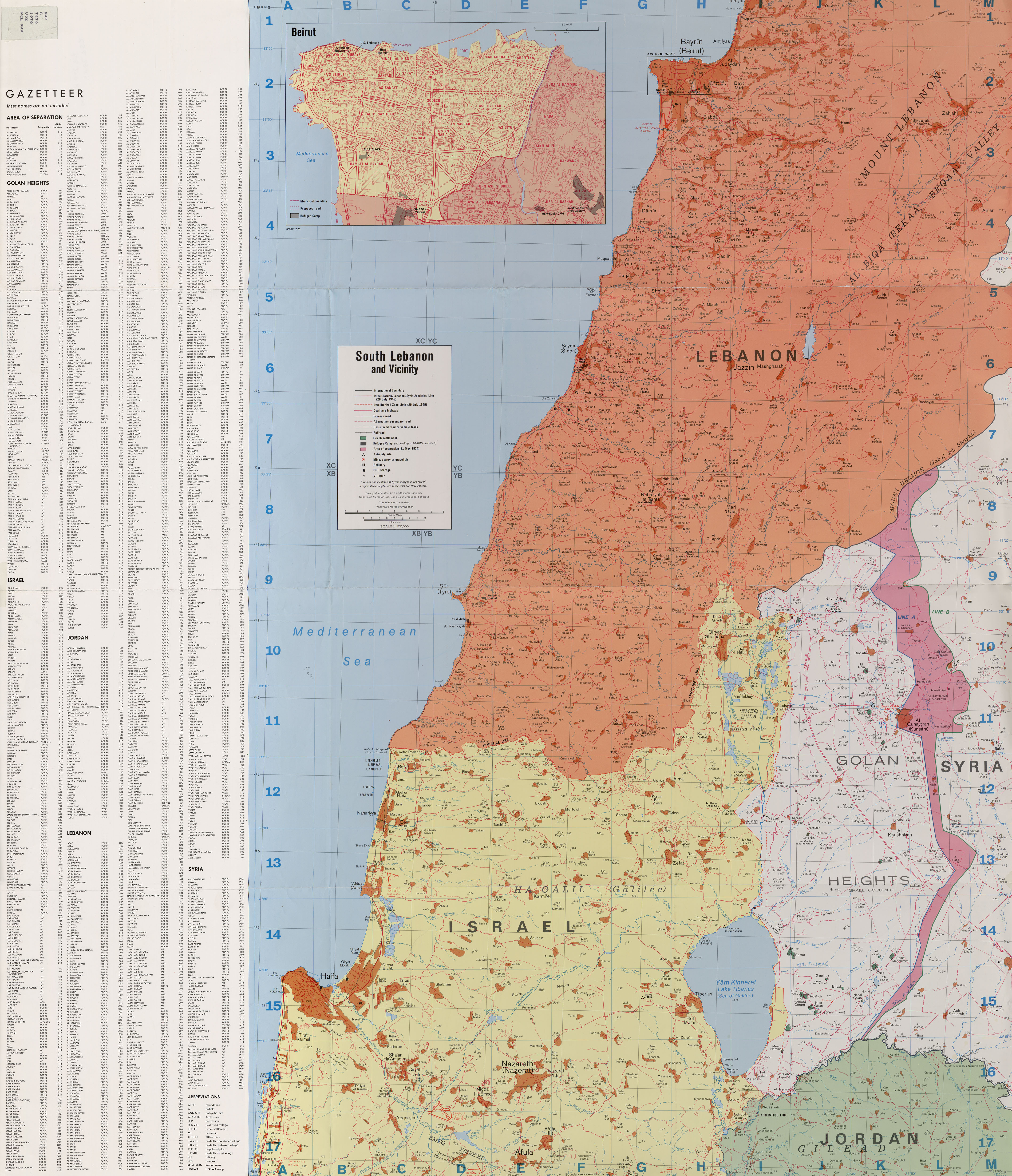
- ^ a b South Lebanon and Vicinity 1976, CIA map.
- ^ Murphy & Gannon 2008, p 48
- ^ Yaqut al-Hamawi, cited in le Strange, 1890, p. 485
- ^ U.S. Committee for Refugees and Immigrants[pranala nonaktif permanen]
Pranala luar sunting
- Golan Heights and Vicinity: October 1994 – CIA map of the Golan Heights, at the Library of Congress, showing abandoned/dismantled Syrian villages.
- South Lebanon and Vicinity 1976 – Map from the University of Texas at Austin, showing Syrian villages in the Golan Heights from pre-1967 sources.
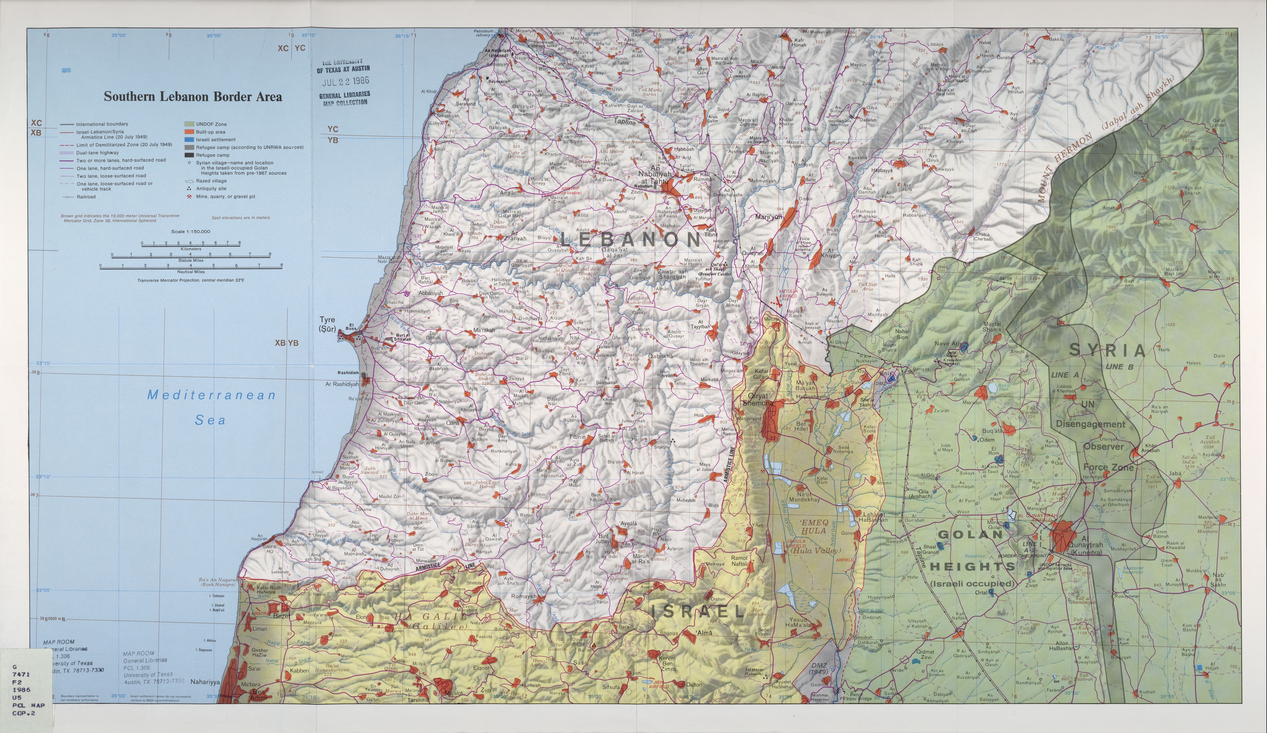
- Southern Lebanon Border Area 1986 – Map from the University of Texas at Austin general libraries map collection, showing Syrian villages in the Golan Heights from pre-1967 sources.