Berkas:Somaliland. Anglo-Italian Boundary Commission 1929-1930. Index to Field sheets etc. War Office ledger (WOOS-33-1).jpg

Ukuran pratayang ini: 586 × 600 piksel. Resolusi lainnya: 234 × 240 piksel | 469 × 480 piksel | 750 × 768 piksel | 1.000 × 1.024 piksel | 2.001 × 2.048 piksel | 5.405 × 5.533 piksel.
Ukuran asli (5.405 × 5.533 piksel, ukuran berkas: 24,95 MB, tipe MIME: image/jpeg)
Ringkasan
; ;
| Judul |
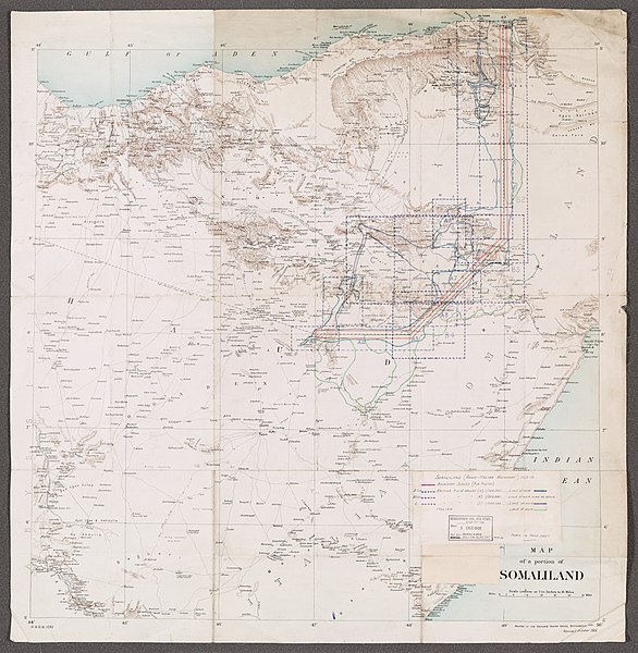
Somaliland. Anglo-Italian Boundary Commission 1929-1930.' 'Index to Field sheets etc.' - War Office ledger (WOOS/33/1) |
|||||||||||||||||||||||
| Deskripsi |
Graphic index portraying extent of Boundary Survey (air photos), British field sheets and Italian field sheets, as filed at WOOS/33/2. Information added in manuscript to lithographed base map. Legend affixed to map face.Base map is G.S.G.S. 1781, revised October 1906 as T.S.G.S. 1781, titled 'Map of a portion of Somaliland' and filed at Maps MOD IDWO 1781. Portrays hydrology, relief by form lines and spot heights, roads and tracks, settlements, water sources, international boundaries and place names. Creation start date derived from earliest use of designation 'G.S.G.S.' |
|||||||||||||||||||||||
| British Library Shelfmark | WOOS/33/1 | |||||||||||||||||||||||
| Locations Depicted | British Somaliland, Africa, 1884-1960 Italian Somaliland, Africa, 1889-1936 | |||||||||||||||||||||||
| Centre Point Coordinates | 8.0000,47.0000 | |||||||||||||||||||||||
| Tanggal | [1909]-1930 | |||||||||||||||||||||||
| Sumber |
|
|||||||||||||||||||||||
| Pencipta |
Anglo-Italian Somaliland Boundary Commission, 1929-1930, Publisher Phipps, John Faviell, 1894-1964, army officer, Surveyor Stafford, John Howard, fl 1918-1966, army officer, Surveyor Taylor, Richard Harold Redvers, 1900-1975, army officer and artist, Surveyor |
|||||||||||||||||||||||
| Izin (Menggunakan kembali berkas ini) |
|
|||||||||||||||||||||||
| Geotemporal data | ||||||||||||||||||||||||
| Map location | Somaliland | |||||||||||||||||||||||
| Scale | Scale 1:1,000,000 | |||||||||||||||||||||||
| Bounding box |
|
|||||||||||||||||||||||
| Georeferencing | If inappropriate please set warp_status = skip to hide. | |||||||||||||||||||||||
| Archival data | ||||||||||||||||||||||||
| Koleksi |
|
|||||||||||||||||||||||
| Ukuran | 74 x 73cm | |||||||||||||||||||||||
| Bahan | Printed, with manuscript additions in coloured ink, watercolour and pencil | |||||||||||||||||||||||
| Catatan | For more information please see the British Library’s Collection Guide to the War Office Archive. | |||||||||||||||||||||||

.svg)


.jpg)
.jpg¶ms=11.0000_N_44.0000_E_)
.jpg¶ms=11.0000_N_50.0000_E_)
.jpg¶ms=5.0000_N_44.0000_E_)
.jpg¶ms=5.0000_N_50.0000_E_)
Riwayat berkas
Klik pada tanggal/waktu untuk melihat berkas ini pada saat tersebut.
| Tanggal/Waktu | Miniatur | Dimensi | Pengguna | Komentar | |
|---|---|---|---|---|---|
| terkini | 28 Maret 2018 12.09 | | 5.405 × 5.533 (24,95 MB) | Ndalyrose | GWToolset: Creating mediafile for Ndalyrose. |
Penggunaan berkas
Halaman berikut menggunakan berkas ini:
Penggunaan berkas global
Wiki lain berikut menggunakan berkas ini:
- Penggunaan pada ar.wikipedia.org
- Penggunaan pada en.wikipedia.org
- Penggunaan pada so.wikipedia.org
.jpg)