Berkas:ShepherdByzempire1265.jpg
Ukuran asli (1.144 × 900 piksel, ukuran berkas: 281 KB, tipe MIME: image/jpeg)
Ringkasan
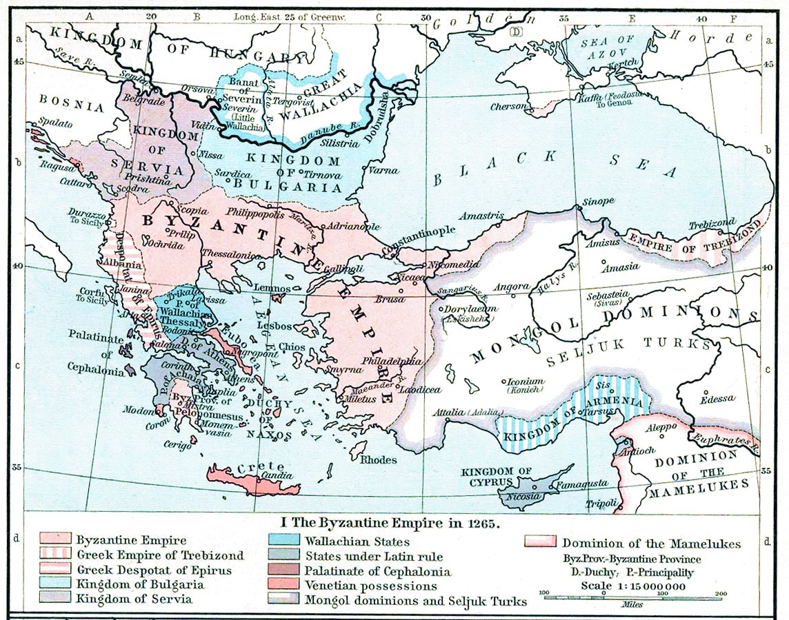
| Deskripsi | Map, The Byzantine Empire, 1265. | ||||||||||||||||||||||
| Tanggal | |||||||||||||||||||||||
| Sumber | The Historical Atlas, William R. Shepherd, 1911. | ||||||||||||||||||||||
| Pembuat |
|
||||||||||||||||||||||
| Versi lainnya |
Karya turunan dari berkas ini: |
||||||||||||||||||||||


Lisensi
|
This work is in the public domain in its country of origin and other countries and areas where the copyright term is the author's life plus 70 years or fewer.
| |
| Berkas ini telah diidentifikasi bebas dari pembatasan menurut hukum hak cipta termasuk semua hak terkait dan relevan. | |
This media file is in the public domain in the United States. This applies to U.S. works where the copyright has expired, often because its first publication occurred prior to January 1, 1929, and if not then due to lack of notice or renewal. See this page for further explanation.
|
 | |
 |
This image might not be in the public domain outside of the United States; this especially applies in the countries and areas that do not apply the rule of the shorter term for US works, such as Canada, Mainland China (not Hong Kong or Macao), Germany, Mexico, and Switzerland. The creator and year of publication are essential information and must be provided. See Wikipedia:Public domain and Wikipedia:Copyrights for more details.
|
Riwayat berkas
Klik pada tanggal/waktu untuk melihat berkas ini pada saat tersebut.
| Tanggal/Waktu | Miniatur | Dimensi | Pengguna | Komentar | |
|---|---|---|---|---|---|
| terkini | 16 November 2022 15.28 | | 1.144 × 900 (281 KB) | Gyalu22 | Reverted to version as of 16:26, 12 July 2009 (UTC) |
| 20 Mei 2016 14.49 |  | 1.144 × 900 (858 KB) | Julieta39 | Cosmetic (see discussion file) | |
| 12 Juli 2009 16.26 |  | 1.144 × 900 (281 KB) | Alex:D | whitened | |
| 12 Juli 2009 16.17 |  | 1.144 × 900 (281 KB) | Alex:D | whitened | |
| 12 Juli 2009 16.12 |  | 1.144 × 900 (281 KB) | Alex:D | whitened | |
| 21 Desember 2004 13.40 |  | 1.144 × 900 (272 KB) | Mschlindwein | Map, The Byzantine Empire, 1265. The Historical Atlas, William R. Shepherd, 1911. |
Penggunaan berkas
2 halaman berikut menggunakan berkas ini:
Penggunaan berkas global
Wiki lain berikut menggunakan berkas ini:
- Penggunaan pada an.wikipedia.org
- Penggunaan pada ar.wikipedia.org
- Penggunaan pada azb.wikipedia.org
- Penggunaan pada az.wikipedia.org
- Penggunaan pada be-tarask.wikipedia.org
- Penggunaan pada be.wikipedia.org
- Penggunaan pada bg.wikipedia.org
- Penggunaan pada ca.wikipedia.org
- Penggunaan pada cs.wikipedia.org
- Penggunaan pada de.wikipedia.org
- Penggunaan pada el.wikipedia.org
- Penggunaan pada en.wikipedia.org
Lihat lebih banyak penggunaan global dari berkas ini.