Berkas:Land given up to Silesian dukes (Dr. T. Szulc).jpg

Ukuran asli (1.266 × 779 piksel, ukuran berkas: 218 KB, tipe MIME: image/jpeg)
.jpg)
| Deskripsi |
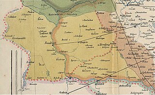
English: Part of a historical map of Greater Poland (Middle Ages) made by Dr. T. Szulc and included in the 4th volume of Codex diplomaticus Maioris Poloniae, covering a Lubusz Land and land given up to Silesian dukes by the Greatpoland dukes Polski: Fragment historycznej mapy Wielkopolski w epoce piastowskiej wykonanej przez Dr. T. Szulca i zamieszczonej w czwartym tomie Kodeksu dyplomatycznego Wielkopolski, obrazujący Ziemię Lubuską (granice diecezji lubuskiej) oraz obszar odstąpiony książętom śląskim przez książąt wielkopolskich |
| Tanggal | (UTC) |
| Sumber | |
| Pembuat |
|
| Ini merupakan gambar hasil penyuntingan yang berarti bahwa gambar tersebut telah diubah secara digital dari versi asli. Perubahan: Extracting part of the map to cover Lubusz Land. Versi asli dapat dilihat di sini: WielkoPolska epoki Piastowskiej.jpg:
|
|
This work is in the public domain in its country of origin and other countries and areas where the copyright term is the author's life plus 70 years or fewer.
| |
| Berkas ini telah diidentifikasi bebas dari pembatasan menurut hukum hak cipta termasuk semua hak terkait dan relevan. | |
Log pengunggahan asli
This image is a derivative work of the following images:
- File:WielkoPolska_epoki_Piastowskiej.jpg licensed with PD-old
- 2009-06-22T15:28:59Z Paelius 4075x3613 (10969409 Bytes) {{Information |Description={{en|1=Historical map of Greater Poland (Middle Ages) made by Dr. T. Szulc and included in the 4th volume of Codex diplomaticus Maioris Poloniae}} {{pl|1=Historyczna mapa Wielkopolski w epoce piasto
Uploaded with derivativeFX
Riwayat berkas
Klik pada tanggal/waktu untuk melihat berkas ini pada saat tersebut.
| Tanggal/Waktu | Miniatur | Dimensi | Pengguna | Komentar | |
|---|---|---|---|---|---|
| terkini | 14 Januari 2022 12.32 | | 1.266 × 779 (218 KB) | Davey2010 | rv vandal - please seek consensus for your changes |
| 13 Januari 2022 19.13 |  | 1.023 × 1.056 (362 KB) | LechitaPL | Reverted to version as of 20:25, 19 September 2021 (UTC) (vandalized) | |
| 13 Januari 2022 01.23 |  | 1.266 × 779 (218 KB) | Davey2010 | Reverted to version as of 12:21, 19 August 2009 (UTC) | |
| 19 September 2021 20.25 |  | 1.023 × 1.056 (362 KB) | LechitaPL | Zmiany | |
| 19 Agustus 2009 12.21 |  | 1.266 × 779 (218 KB) | Opole.pl | {{Information |Description={{en|1=Part of a historical map of Greater Poland (Middle Ages) made by Dr. T. Szulc and included in the 4th volume of Codex diplomaticus Maioris Poloniae, covering Lubusz Land}} {{pl|1=Fragment historycznej mapy Wielkopolski w |
Penggunaan berkas
Tidak ada halaman yang menggunakan berkas ini.
Penggunaan berkas global
Wiki lain berikut menggunakan berkas ini:
- Penggunaan pada ar.wikipedia.org
- Penggunaan pada fr.wikipedia.org
- Penggunaan pada ru.wikipedia.org
.jpg)