Berkas:Historical Map of Sikkim in northeastern India.jpg

Ukuran asli (4.510 × 3.916 piksel, ukuran berkas: 14,76 MB, tipe MIME: image/jpeg)
Ringkasan
Lisensi
This media file is in the public domain in the United States. This applies to U.S. works where the copyright has expired, often because its first publication occurred prior to January 1, 1929, and if not then due to lack of notice or renewal. See this page for further explanation.
|
 | |
 |
This image might not be in the public domain outside of the United States; this especially applies in the countries and areas that do not apply the rule of the shorter term for US works, such as Canada, Mainland China (not Hong Kong or Macao), Germany, Mexico, and Switzerland. The creator and year of publication are essential information and must be provided. See Wikipedia:Public domain and Wikipedia:Copyrights for more details.
|
|
Ini adalah suatu perbanyakan fotografis dari sebuah karya seni dua dimensi. Karya seni tersebut berada pada domain publik karena alasan berikut:
Posisi resmi Wikimedia Foundation adalah bahwa "faithful reproductions of two-dimensional public domain works of art are public domain, and that claims to the contrary represent an assault on the very concept of a public domain". Untuk detilnya, lihat Commons:When to use the PD-Art tag.
Oleh karena itu, perbanyakan fotografis ini juga dianggap berada pada domain publik. Mohon diperhatikan bahwa hukum lokal mungkin saja melarang atau membatasi penggunaan kembali berkas ini di wilayah hukum anda. Lihat Commons:Reuse of PD-Art photographs. | ||||
Log pengunggahan asli
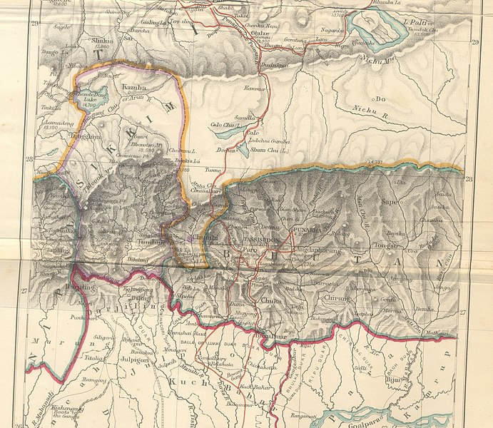
- 2009-10-14 10:25 Hindutashravi 4510×3916× (15480075 bytes) Historical Map of Sikkim in northeastern India extracted from map prepared by Trelawney Saunders, 1876 titled The routes of Bogle, Turner and Manning between Bengal and Tibet, and published in the book Titled, Narratives of the Mission of George Bogle
Riwayat berkas
Klik pada tanggal/waktu untuk melihat berkas ini pada saat tersebut.
| Tanggal/Waktu | Miniatur | Dimensi | Pengguna | Komentar | |
|---|---|---|---|---|---|
| terkini | 25 Juni 2010 07.38 | | 4.510 × 3.916 (14,76 MB) | File Upload Bot (Magnus Manske) | {{BotMoveToCommons|en.wikipedia|year={{subst:CURRENTYEAR}}|month={{subst:CURRENTMONTHNAME}}|day={{subst:CURRENTDAY}}}} {{Information |Description={{en|Historical Map of Sikkim in northeastern India extracted from map prepared by Trelawney Saunders, 1876 |
Penggunaan berkas
Halaman berikut menggunakan berkas ini:
Penggunaan berkas global
Wiki lain berikut menggunakan berkas ini:
- Penggunaan pada as.wikipedia.org
- Penggunaan pada bn.wikipedia.org
- Penggunaan pada en.wikipedia.org
- Penggunaan pada gu.wikipedia.org
- Penggunaan pada he.wikipedia.org
- Penggunaan pada hi.wikipedia.org
- Penggunaan pada ja.wikipedia.org
- Penggunaan pada kn.wikipedia.org
- Penggunaan pada my.wikipedia.org
- Penggunaan pada nl.wikipedia.org
- Penggunaan pada pt.wikipedia.org
- Penggunaan pada sa.wikipedia.org
- Penggunaan pada si.wikipedia.org
- Penggunaan pada ta.wikipedia.org
- Penggunaan pada th.wikipedia.org
- Penggunaan pada vi.wikipedia.org