Berkas:Gulf of Izmit, Turkey.JPG

Ukuran pratayang ini: 800 × 532 piksel. Resolusi lainnya: 320 × 213 piksel | 640 × 425 piksel | 1.024 × 681 piksel | 1.280 × 851 piksel | 2.560 × 1.701 piksel | 4.288 × 2.850 piksel.
Ukuran asli (4.288 × 2.850 piksel, ukuran berkas: 2,6 MB, tipe MIME: image/jpeg)
Ringkasan
| Deskripsi |
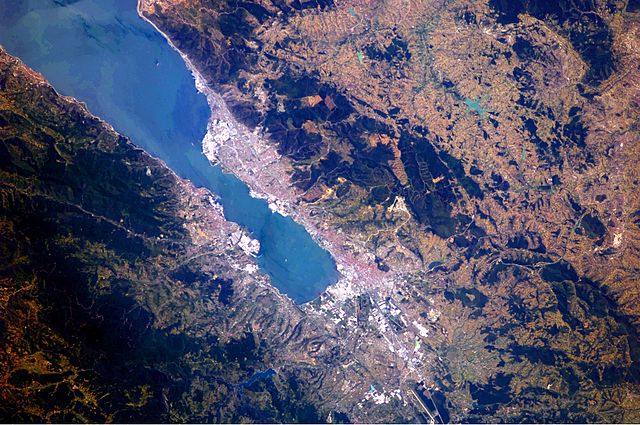
English: This astronaut photograph highlights the metropolitan area of Izmit along the northern and eastern shores of the Sea of Marmara, at the end of the Gulf of Izmit. Commercial and industrial centres—including petroleum refineries and automobile factories—are recognizable by large structures with white rooftops. The smaller city of Gölcük on the southern shoreline of the Gulf is the location of a Turkish naval facility and another automobile factory. Both urban areas are built primarily on flat lowlands adjacent to the Gulf, with green vegetation marking highland areas to the north of Izmit and south of Gölcük. |
| Tanggal | |
| Sumber | NASA Earth Observatory |
| Pembuat | ISS Expedition 24 crew |
| Lokasi kamera | | Lihat gambar ini dan gambar di sekitarnya di: OpenStreetMap |
|---|
Gambar atau video ini telah dikatalogkan oleh Pusat Antariksa Johnson milik National Aeronautics and Space Administration (NASA)dibawah ID Foto: ISS024-E-10162. Label ini tidak menunjukkan status hak cipta dari berkas. Label hak cipta yang biasa tetap dibutuhkan. Lihat Commons:Lisensi. Bahasa lain:
|
Image acquired with a Nikon D2Xs digital camera using a 180 mm lens, and is provided by the ISS Crew Earth Observations experiment and Image Science & Analysis Laboratory, Johnson Space Center.
Lisensi
| Berkas ini berada dalam domain publik di Amerika Serikat karena semata-mata diciptakan oleh NASA. Kebijakan hak cipta NASA menyatakan bahwa "materi NASA tidak dilindungi oleh hak cipta kecuali dicatat". (Lihat Template:PD-USGov, Halaman kebijakan hak cipta NASA atau JPL Image Use Policy.) | ||
 |
Peringatan:
|
Riwayat berkas
Klik pada tanggal/waktu untuk melihat berkas ini pada saat tersebut.
| Tanggal/Waktu | Miniatur | Dimensi | Pengguna | Komentar | |
|---|---|---|---|---|---|
| terkini | 23 Agustus 2010 09.56 | | 4.288 × 2.850 (2,6 MB) | Originalwana | {{Information |Description={{en|1=This astronaut photograph highlights the metropolitan area of Izmit along the northern and eastern shores of the Sea of Marmara, at the end of the Gulf of Izmit. [[:Category:Commerc |
Penggunaan berkas
Halaman berikut menggunakan berkas ini:
Penggunaan berkas global
Wiki lain berikut menggunakan berkas ini:
- Penggunaan pada ar.wikipedia.org
- Penggunaan pada az.wikipedia.org
- Penggunaan pada ba.wikipedia.org
- Penggunaan pada bg.wikipedia.org
- Penggunaan pada bn.wikipedia.org
- Penggunaan pada ca.wikipedia.org
- Penggunaan pada ceb.wikipedia.org
- Penggunaan pada cs.wikipedia.org
- Penggunaan pada en.wikipedia.org
- Penggunaan pada es.wikipedia.org
- Penggunaan pada eu.wikipedia.org
- Penggunaan pada fa.wikipedia.org
- Penggunaan pada fr.wikipedia.org
- Penggunaan pada he.wikipedia.org
- Penggunaan pada hr.wikipedia.org
- Penggunaan pada ilo.wikipedia.org
- Penggunaan pada it.wikipedia.org
- Penggunaan pada ka.wikipedia.org
- Penggunaan pada mt.wikipedia.org
- Penggunaan pada nl.wikipedia.org
- Penggunaan pada nn.wikipedia.org
- Penggunaan pada ru.wikipedia.org
- Penggunaan pada tr.wikipedia.org
- Penggunaan pada tr.wikivoyage.org
- Penggunaan pada www.wikidata.org
- Penggunaan pada zh.wikipedia.org