Berkas:Greater Croatia 01.png
Ukuran pratayang ini: 663 × 600 piksel. Resolusi lainnya: 265 × 240 piksel | 531 × 480 piksel | 849 × 768 piksel | 1.151 × 1.041 piksel.
Ukuran asli (1.151 × 1.041 piksel, ukuran berkas: 153 KB, tipe MIME: image/png)
Ringkasan
| Deskripsi |
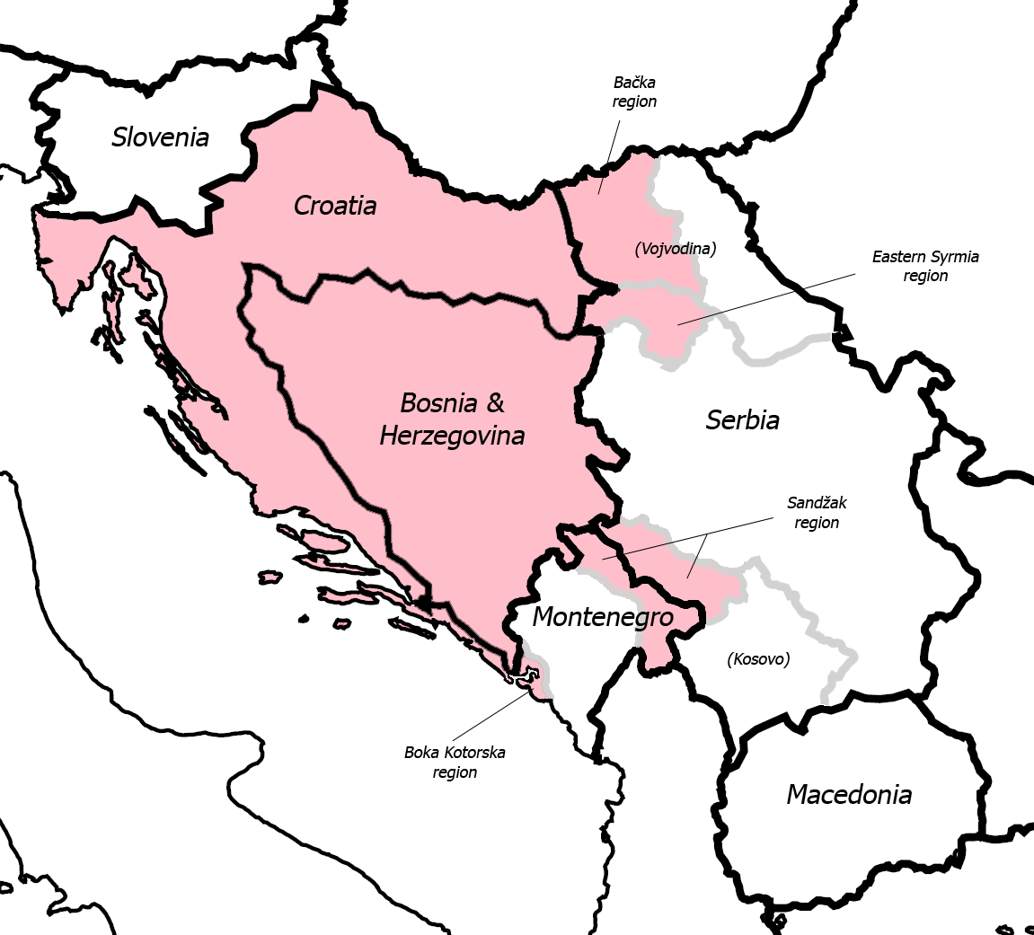
English: Fixed some detail, used overlaid Sandzak, Backa & Syrmium regions so it's much more accurate now. Pink coloring denotes regions claimed by Greater Croatian proponents. Current country borders are black, regional borders (only those that are relevant to the article) are grey.
CommentMap is still wrong:) Croatian-Slovenian border in Istria is 20 kilometars southern that it should be (Umag and Savudrija are in Croatia, hej!) And borders of eastern Srijem are not correct (Zemun and Novi Beograd are part of Srijem, too).
|
| Tanggal | 24 Mei 2006 (original upload date) |
| Sumber | Dipindahkan dari en.wikipedia ke Commons. |
| Pembuat | Dr.Gonzo di Wikipedia bahasa Inggris |
| Versi lainnya |
|


Lisensi
| Karya ini dilepaskan ke domain umum oleh pemiliknya, Dr.Gonzo di Wikipedia bahasa Inggris. Lisensi ini berlaku di seluruh dunia. Di sejumlah negara, tindakan ini tidak memungkinkan secara sah; bila seperti itu: Dr.Gonzo memberikan siapa pun hak untuk menggunakan karya ini untuk tujuan apa pun, tanpa persyaratan apa pun, kecuali yang ditetapkan oleh hukum. |
Log pengunggahan asli
Halaman deskripsi aslinya ada di sini. Semua nama pengguna berikut merujuk pada en.wikipedia.
- 2007-03-13 10:42 Dr.Gonzo 1151×1041×8 (156832 bytes) Fixed the Istria border (sorry for that, the blank map I used already had that mistake)
- 2006-05-24 22:25 Dr.Gonzo 1151×1041×8 (154088 bytes) Fixed some detail, used overlayed Sandzak, Backa & Syrmium regions so it's much more accurate now.
- 2006-05-24 19:10 Dr.Gonzo 1151×1041×8 (153078 bytes) First version, self made. Some minor geographical detail may be incorrect. Pink coloring denotes regions claimed by Greater Croatian proponents.
Riwayat berkas
Klik pada tanggal/waktu untuk melihat berkas ini pada saat tersebut.
| Tanggal/Waktu | Miniatur | Dimensi | Pengguna | Komentar | |
|---|---|---|---|---|---|
| terkini | 25 Februari 2008 22.40 | | 1.151 × 1.041 (153 KB) | File Upload Bot (Magnus Manske) | {{BotMoveToCommons|en.wikipedia}} {{Information |Description={{en|Fixed some detail, used overlaid Sandzak, Backa & Syrmium regions so it's much more accurate now. Pink coloring denotes regions claimed by Greater Croatian proponents. Current country bord |
Penggunaan berkas
Halaman berikut menggunakan berkas ini:
Penggunaan berkas global
Wiki lain berikut menggunakan berkas ini:
- Penggunaan pada ar.wikipedia.org
- Penggunaan pada bs.wikipedia.org
- Penggunaan pada cs.wikipedia.org
- Penggunaan pada de.wikipedia.org
- Penggunaan pada el.wikipedia.org
- Penggunaan pada en.wikipedia.org
- Penggunaan pada ja.wikipedia.org
- Penggunaan pada pt.wikipedia.org
- Penggunaan pada sh.wikipedia.org
- Penggunaan pada sr.wikipedia.org
- Penggunaan pada uk.wikipedia.org
- Penggunaan pada www.wikidata.org