Berkas:Ghaznavid Empire 975 - 1187 (AD).PNG
Tak tersedia resolusi yang lebih tinggi.
Ghaznavid_Empire_975_-_1187_(AD).PNG (620 × 428 piksel, ukuran berkas: 20 KB, tipe MIME: image/png)
.PNG)
Ringkasan
| Deskripsi |
Polski: Państwo Ghaznawidów
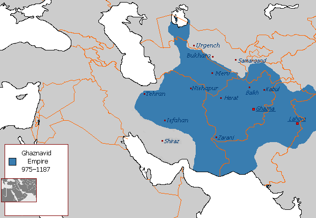
English: Ghaznavid Empire |
| Tanggal | |
| Sumber | Karya sendiri |
| Pembuat | Arab League |
| Versi lainnya | Arabic |
-ar.PNG)
Lisensi
| Karya ini dilepaskan ke domain umum oleh pemiliknya, Arab League di Wikipedia bahasa Inggris. Lisensi ini berlaku di seluruh dunia. Di sejumlah negara, tindakan ini tidak memungkinkan secara sah; bila seperti itu: Arab League memberikan siapa pun hak untuk menggunakan karya ini untuk tujuan apa pun, tanpa persyaratan apa pun, kecuali yang ditetapkan oleh hukum. |
Riwayat berkas
Klik pada tanggal/waktu untuk melihat berkas ini pada saat tersebut.
.PNG&dir=prev)
.PNG&offset=20130607145450)
.PNG&offset=&limit=20)
.PNG&offset=&limit=50)
.PNG&offset=&limit=100)
.PNG&offset=&limit=250)
.PNG&offset=&limit=500)
| Tanggal/Waktu | Miniatur | Dimensi | Pengguna | Komentar | |
|---|---|---|---|---|---|
| terkini | 7 Juli 2015 04.54 | | 620 × 428 (20 KB) | HistoryofIran | Of course Iranica doesn't, it states which areas they ruled at their extent, stop making reverts without discussing.. |
| 4 Juli 2015 01.05 |  | 619 × 428 (21 KB) | Persia10101 | More accurate map after some research | |
| 4 Juli 2015 01.05 |  | 619 × 428 (21 KB) | Persia10101 | More accurate map after some research | |
| 4 Juli 2015 00.58 |  | 620 × 428 (26 KB) | Persia10101 | Iranica doesnt show a map. reverting to the more commonly agreed map | |
| 4 Juli 2015 00.57 |  | 620 × 428 (26 KB) | Persia10101 | Reverted to version as of 08:05, 14 August 2011 | |
| 9 Mei 2014 12.08 |  | 620 × 428 (20 KB) | HistoryofIran | Further fixed the map, i will be adding vassals later. | |
| 28 Januari 2014 23.47 |  | 620 × 428 (20 KB) | HistoryofIran | Fars and Kerman remained under Buyid rule until the Seljuqs came. | |
| 7 Juni 2013 15.01 |  | 620 × 428 (20 KB) | HistoryofIran | Fixed the map, according to Iranica the map was like this at it's greatest extent. | |
| 7 Juni 2013 14.58 |  | 620 × 428 (20 KB) | HistoryofIran | Fixed the map, according to Iranica the map was like this at it's greatest extent. | |
| 7 Juni 2013 14.54 |  | 620 × 428 (20 KB) | HistoryofIran | Fixed the map, according to Iranica the map was like this at it's greatest extent. |
Penggunaan berkas
5 halaman berikut menggunakan berkas ini:
Penggunaan berkas global
Wiki lain berikut menggunakan berkas ini:
- Penggunaan pada arz.wikipedia.org
- Penggunaan pada ast.wikipedia.org
- Penggunaan pada av.wikipedia.org
- Penggunaan pada azb.wikipedia.org
- Penggunaan pada az.wikipedia.org
- Penggunaan pada ba.wikipedia.org
- Penggunaan pada be.wikipedia.org
- Penggunaan pada bg.wikipedia.org
- Penggunaan pada bn.wikipedia.org
- Penggunaan pada ca.wikipedia.org
- Penggunaan pada ceb.wikipedia.org
- Penggunaan pada ckb.wikipedia.org
- Penggunaan pada da.wikipedia.org
- Penggunaan pada de.wikipedia.org
- Penggunaan pada el.wikipedia.org
- Penggunaan pada en.wikipedia.org
- Muslim conquests of Afghanistan
- History of Afghanistan
- Turkic peoples
- Greater Iran
- Jasrota
- User:Arab Hafez/Map
- Portal:Afghanistan
- Shia Islam in the Indian subcontinent
- User:Ottava Rima/Persian Empire
- User:Sobreira/Religion
- Muslim conquest of Khorasan
- Nurpur kingdom
- User:Northamerica1000/Portals of the world
- User:Kansas Bear/Ghaznavids
- User:Kypioys sx/sandbox
- User:Kansas Bear/Saffarid dynasty
- Penggunaan pada eo.wikipedia.org
- Penggunaan pada es.wikipedia.org
Lihat lebih banyak penggunaan global dari berkas ini.
.PNG)
.PNG)