Berkas:East and West Florida 1810.jpg
East_and_West_Florida_1810.jpg (412 × 245 piksel, ukuran berkas: 44 KB, tipe MIME: image/jpeg)
| Deskripsi |
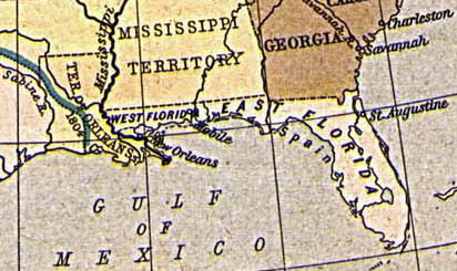
English: Map of East and West Florida in 1810, from the Perry-Castañeda Map Collection [1]. The boundary between the two provinces is incorrect; it was at the Apalachicola River, not the Perdido River (as shown here).
Español: Mapa de Florida Oriental y Florida Occidental en 1810, de la Collección Perry-Castañeda de Mapas[2]. La frontera entre las dos provincias no es correcto; la frontera era el Rio Apalachicola, no el Perdido (como se aparece aquí).
Deutsch: Karte von Ost- und Westflorida 1810. Aus der Kartensammlung der Perry-Castañeda Bibliothek[3]. Die Grenze zwischen Ost- und Westflorida ist unrichtig; die richtige Grenze war der Apalachicola-Fluss anstatt dem Perdido.
Français : Carte de Floride occidentale et de Floride orientale en 1810, provenant de la collection cartographique Perry-Castañeda [4].
La frontière indiquée entre les deux provinces est erronée : elle était formée par le fleuve Apalachicola, et non le fleuve Perdido représenté ici. |
||||||||||||||||||||||
| Tanggal | 1923. Provided on 11 August 2005 by en:User:JW1805 to the English Wikipedia. | ||||||||||||||||||||||
| Sumber | From "The Historical Atlas" by William R. Shepherd, 1923. http://www.lib.utexas.edu/maps/historical/shepherd/us_expansion_shepherd.jpg | ||||||||||||||||||||||
| Pembuat |
|
||||||||||||||||||||||
![[1]](http://www.lib.utexas.edu/maps/historical/shepherd/us_expansion_shepherd.jpg)
|
This work is in the public domain in its country of origin and other countries and areas where the copyright term is the author's life plus 70 years or fewer.
| |
| Berkas ini telah diidentifikasi bebas dari pembatasan menurut hukum hak cipta termasuk semua hak terkait dan relevan. | |
Riwayat berkas
Klik pada tanggal/waktu untuk melihat berkas ini pada saat tersebut.
| Tanggal/Waktu | Miniatur | Dimensi | Pengguna | Komentar | |
|---|---|---|---|---|---|
| terkini | 20 Agustus 2005 13.30 | | 412 × 245 (44 KB) | Sebastian Wallroth | '''en: ''' Map of East and West Florida in 1810. From the Perry-Castañeda Library Map Collection [http://www.lib.utexas.edu/maps/historical/shepherd/us_expansion_shepherd.jpg]. '''de:''' Karte von Ost- und Westflorida 1810. Aus der Kartensammlung der |
Penggunaan berkas
2 halaman berikut menggunakan berkas ini:
Penggunaan berkas global
Wiki lain berikut menggunakan berkas ini:
- Penggunaan pada br.wikipedia.org
- Penggunaan pada ca.wikipedia.org
- Penggunaan pada da.wikipedia.org
- Penggunaan pada de.wikipedia.org
- Penggunaan pada es.wikipedia.org
- Penggunaan pada fr.wikipedia.org
- Penggunaan pada gl.wikipedia.org
- Penggunaan pada hi.wikipedia.org
- Penggunaan pada hu.wikipedia.org
- Penggunaan pada it.wikipedia.org
- Penggunaan pada ja.wikipedia.org
- Penggunaan pada ko.wikipedia.org
- Penggunaan pada mk.wikipedia.org
- Penggunaan pada nn.wikipedia.org
- Penggunaan pada no.wikipedia.org
- Penggunaan pada pam.wikipedia.org
- Penggunaan pada pt.wikipedia.org
- Penggunaan pada ro.wikipedia.org
- Penggunaan pada ru.wikipedia.org
- Penggunaan pada sco.wikipedia.org
- Penggunaan pada sv.wikipedia.org