Berkas:China's 2009 nine-dash line map submission to the UN.pdf

Ukuran asli (1.275 × 1.650 piksel, ukuran berkas: 412 KB, tipe MIME: application/pdf)
Ringkasan
| Deskripsi |
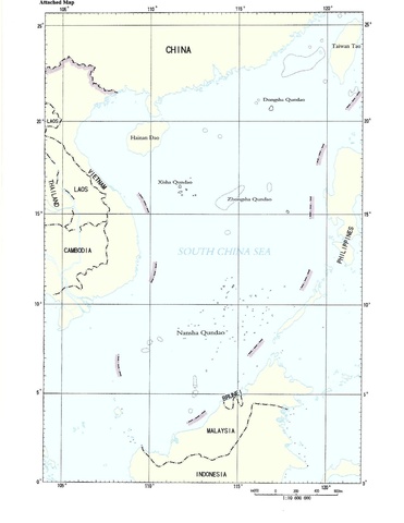
English: Document “CML/17/2009” May 7, 2009, submitted by the People's Republic of China to the United Nations Commission on the Limits of the Continental Shelf. The map here is the second page in a two-page document. The first page is a text addressed to the UN Secretary General, noting China's sovereignty claim to the "islands in the South China Sea and the adjacent waters", however, the document remains ambiguous by being silent as to the precise meaning of the map enclosed, and the meaning of the nine-dash line on it |
| Tanggal | 05/07/2009 |
| Sumber | United Nations - http://www.un.org/depts/los/clcs_new/submissions_files/mysvnm33_09/chn_2009re_mys_vnm_e.pdf |
| Pembuat | Tak diketahui |
Lisensi
| This image is a map derived from a United Nations map.
Unless stated otherwise, UN maps are to be considered in the public domain. This applies worldwide. UN maps are, in principle, open source material and you can use them in your work or for making your own map. UN requests however that you delete the UN name, logo and reference number upon any modification to the map. Content of your map will be your responsibility. You can state in your publication, if you wish, something like: based on UN map … (map name, map number, revision number and date). See: Geospatial Information Section. And: Geospatial, location data for a better world. |
 |
Riwayat berkas
Klik pada tanggal/waktu untuk melihat berkas ini pada saat tersebut.
| Tanggal/Waktu | Miniatur | Dimensi | Pengguna | Komentar | |
|---|---|---|---|---|---|
| terkini | 20 Februari 2015 16.02 |  | 1.275 × 1.650 (412 KB) | Al83tito | User created page with UploadWizard |
Penggunaan berkas
Halaman berikut menggunakan berkas ini:
Penggunaan berkas global
Wiki lain berikut menggunakan berkas ini:
- Penggunaan pada ca.wikipedia.org
- Penggunaan pada el.wikipedia.org
- Penggunaan pada en.wikipedia.org
- Penggunaan pada es.wikipedia.org
- Penggunaan pada et.wikipedia.org
- Penggunaan pada fr.wikipedia.org
- Penggunaan pada pl.wikipedia.org
- Penggunaan pada ru.wikipedia.org
- Penggunaan pada tl.wikipedia.org
- Penggunaan pada uk.wikipedia.org