Berkas:Boko Haram insurgency map.png

Ukuran pratayang ini: 779 × 599 piksel. Resolusi lainnya: 312 × 240 piksel | 624 × 480 piksel | 998 × 768 piksel | 1.280 × 985 piksel | 1.600 × 1.231 piksel.
Ukuran asli (1.600 × 1.231 piksel, ukuran berkas: 395 KB, tipe MIME: image/png)
Ringkasan

|
File:Boko Haram insurgency map.svg merupakan versi vektor dari berkas ini. Berkas itu harus digunakan menggantikan gambar raster ini.
File:Boko Haram insurgency map.png → File:Boko Haram insurgency map.svg
Untuk informasi lanjutan, lihat Bantuan:SVG. |
 |
| Deskripsi |
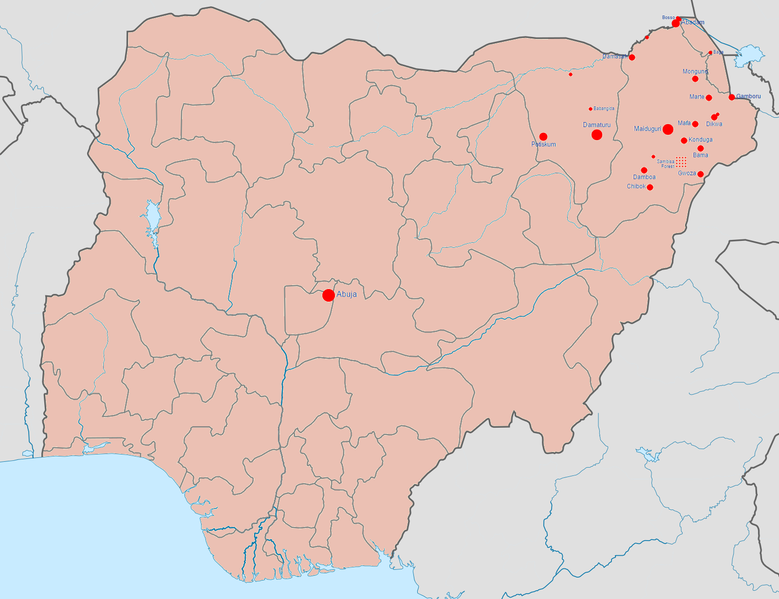
English: Map of the Boko Haram insurgency. The map image is based on Template:Nigerian insurgency detailed map.
Controlled by the Nigerian government
Controlled by Boko Haram/the Islamic State of Iraq and the Levant (variously called ISIL, ISIS, IS, Daesh) |
| Tanggal | |
| Sumber | Karya sendiri |
| Pembuat | BlueHypercane761 |
Lisensi
Saya, pemilik hak cipta dari karya ini, dengan ini menerbitkan berkas ini di bawah ketentuan berikut:
Berkas ini dilisensikan di bawah lisensi Creative Commons Atribusi-Berbagi Serupa 4.0 Internasional.
- Anda diizinkan:
- untuk berbagi – untuk menyalin, mendistribusikan dan memindahkan karya ini
- untuk menggubah – untuk mengadaptasi karya ini
- Berdasarkan ketentuan berikut:
- atribusi – Anda harus mencantumkan atribusi yang sesuai, memberikan pranala ke lisensi, dan memberi tahu bila ada perubahan. Anda dapat melakukannya melalui cara yang Anda inginkan, namun tidak menyatakan bahwa pemberi lisensi mendukung Anda atau penggunaan Anda.
- berbagi serupa – Apabila Anda menggubah, mengubah, atau membuat turunan dari materi ini, Anda harus menyebarluaskan kontribusi Anda di bawah lisensi yang sama seperti lisensi pada materi asli.
Riwayat berkas
Klik pada tanggal/waktu untuk melihat berkas ini pada saat tersebut.
| Tanggal/Waktu | Miniatur | Dimensi | Pengguna | Komentar | |
|---|---|---|---|---|---|
| terkini | 23 Januari 2017 07.08 | | 1.600 × 1.231 (395 KB) | BlueHypercane761 | 1-22-2017 Update. The Nigerian Army and its allies finally annihilated Boko Haram in its last camp in Sambisa Forest (its last known stronghold), on December 24, 2016, reducing Boko Haram to a weakened, insurgent group. |
| 6 Juli 2016 23.41 |  | 1.600 × 1.231 (395 KB) | BlueHypercane761 | 7-6-2016 Update. The Nigerian Army and the Chadian Army completely sealed off the Sambisa Forest region on June 9, 2016, and have captured 50% of the forest. | |
| 25 Desember 2015 22.09 |  | 1.600 × 1.231 (395 KB) | BlueHypercane761 | 12-25-2015 Update. The Nigerian Army has pushed into the heart of Sambisa Forest. | |
| 12 November 2015 06.43 |  | 1.600 × 1.231 (395 KB) | BlueHypercane761 | Update for 11-12-2015. Boko Haram's territorial control was reduced to Sambisa Forest on Septemebr 8, 2015. The situation is current as of November 12, 2015. | |
| 12 November 2015 06.28 |  | 1.600 × 1.231 (395 KB) | BlueHypercane761 | User created page with UploadWizard |
Penggunaan berkas
Halaman berikut menggunakan berkas ini:
Penggunaan berkas global
Wiki lain berikut menggunakan berkas ini:
- Penggunaan pada en.wikipedia.org
- Penggunaan pada es.wikipedia.org
- Penggunaan pada ga.wikipedia.org
- Penggunaan pada ko.wikipedia.org