Berkas:A Map of the Provinces of New York and New Jersey, with a part of Pennsylvania and the Province of Quebec. LOC 74692641 (cropped).jpg

Ukuran pratayang ini: 456 × 600 piksel. Resolusi lainnya: 182 × 240 piksel | 365 × 480 piksel | 584 × 768 piksel | 779 × 1.024 piksel | 1.557 × 2.048 piksel | 5.670 × 7.456 piksel.
Ukuran asli (5.670 × 7.456 piksel, ukuran berkas: 16,53 MB, tipe MIME: image/jpeg)
Ringkasan
| Deskripsi |
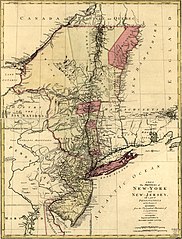
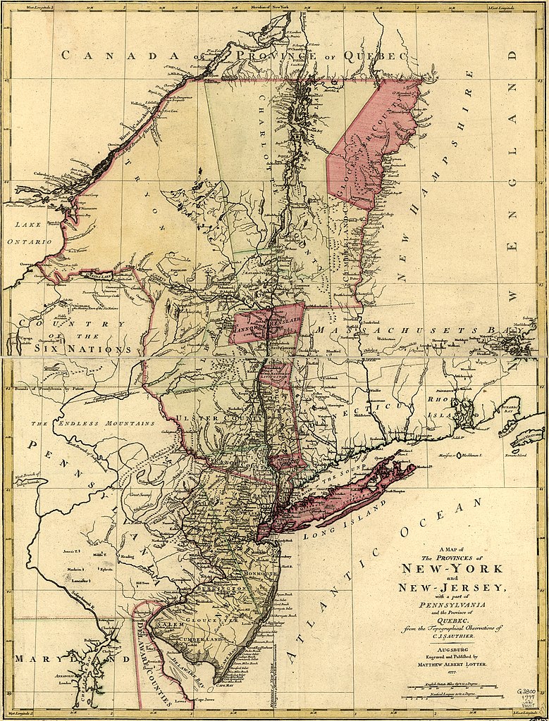
English: Scale ca. 1:1,040,000. Hand colored. LC copy mounted on cloth and paper backing. Prime meridian: New York. Relief shown pictorially. Shows administrative divisions in New York and New Jersey. LC Maps of North America, 1750-1789, 1048 Available also through the Library of Congress Web site as a raster image. Vault AACR2 |
||
| Title | A Map of the Provinces of New York and New Jersey, with a part of Pennsylvania and the Province of Quebec. | ||
| Shelf ID | G3800 1777 .S21 | ||
| Tanggal | |||
| Sumber | https://www.loc.gov/item/74692641/ | ||
| Pembuat | Sauthier, Claude Joseph; Lotter, Matthäus Albrecht | ||
| Izin (Menggunakan kembali berkas ini) |
|
||
| Versi lainnya | |||
| Location | United States · New Jersey · Northeastern States · Québec · New York · New York (State) | ||
| Part of | Military Battles And Campaigns · American Memory · Catalog · Geography And Map Division · American Revolution And Its Era: Maps And Charts Of North America And The West Indies, 1750-1789 | ||
| Subject | United States · New Jersey · Northeastern States · Maps · Early Works To 1800 · Administrative And Political Divisions · New York (State) · Québec (Province) | ||
| Notes | Cropped from .tif |


.jpg)
Lisensi
|
Ini adalah suatu perbanyakan fotografis dari sebuah karya seni dua dimensi. Karya seni tersebut berada pada domain publik karena alasan berikut:
Posisi resmi Wikimedia Foundation adalah bahwa "faithful reproductions of two-dimensional public domain works of art are public domain, and that claims to the contrary represent an assault on the very concept of a public domain". Untuk detilnya, lihat Commons:When to use the PD-Art tag.
Oleh karena itu, perbanyakan fotografis ini juga dianggap berada pada domain publik. Mohon diperhatikan bahwa hukum lokal mungkin saja melarang atau membatasi penggunaan kembali berkas ini di wilayah hukum anda. Lihat Commons:Reuse of PD-Art photographs. | ||||
Riwayat berkas
Klik pada tanggal/waktu untuk melihat berkas ini pada saat tersebut.
| Tanggal/Waktu | Miniatur | Dimensi | Pengguna | Komentar | |
|---|---|---|---|---|---|
| terkini | 29 Maret 2020 13.32 | | 5.670 × 7.456 (16,53 MB) | Zeete | Uploaded a work by Claude Joseph Sauthier from https://www.loc.gov/item/74692641/ with UploadWizard |
Penggunaan berkas
Halaman berikut menggunakan berkas ini:
Penggunaan berkas global
Wiki lain berikut menggunakan berkas ini:
- Penggunaan pada en.wikipedia.org
- Penggunaan pada ml.wikipedia.org
- Penggunaan pada www.wikidata.org
.jpg)