Berkas:Southwest map.png

Ukuran pratayang ini: 800 × 520 piksel. Resolusi lainnya: 320 × 208 piksel | 640 × 416 piksel | 1.024 × 666 piksel | 1.280 × 832 piksel.
Ukuran asli (1.280 × 832 piksel, ukuran berkas: 199 KB, tipe MIME: image/png)
Ringkasan
| Deskripsi |
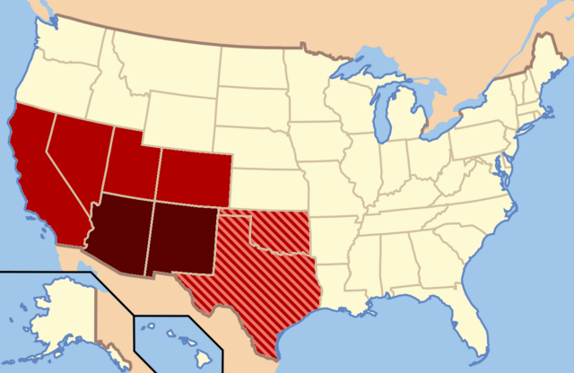
Dark Red: Almost always considered the Southwest |
| Tanggal | |
| Sumber | Karya sendiri |
| Pembuat | Secret Saturdays |
Lisensi
| Saya, pemegang hak cipta karya ini, merilis karya ini ke domain umum. Lisensi ini berlaku di seluruh dunia. Di sejumlah negara, tindakan ini tidak memungkinkan secara sah; bila seperti itu: Saya memberikan siapa pun hak untuk menggunakan karya ini untuk tujuan apa pun, tanpa persyaratan apa pun, kecuali yang ditetapkan oleh hukum. |
Riwayat berkas
Klik pada tanggal/waktu untuk melihat berkas ini pada saat tersebut.
| Tanggal/Waktu | Miniatur | Dimensi | Pengguna | Komentar | |
|---|---|---|---|---|---|
| terkini | 9 Februari 2022 03.20 | | 1.280 × 832 (199 KB) | Quackslikeaduck | Reverted to version as of 20:03, 25 August 2016 (UTC); Kansas is not considered part of the American Southwest, not even geographically. |
| 31 Juli 2020 21.39 |  | 1.280 × 832 (159 KB) | Rubensbathsheba | Kansas may sometimes be considered part of the Southwest geographically. | |
| 25 Agustus 2016 20.03 |  | 1.280 × 832 (199 KB) | WClarke | Instead of using dark red, red, and blue stripes, this version uses dark red, red, and red stripes. Everything being red makes the map look more uniform. | |
| 23 Juli 2009 22.53 |  | 572 × 371 (21 KB) | Secret Saturdays | {{Information |Description={{en|1=The Dark Red states mean they are almost always considered Southwest states, The light red states mean they are rarely considered Southwest states and the Blue States mean they are conisdered Southwest and Southern states |
Penggunaan berkas
Halaman berikut menggunakan berkas ini:
Penggunaan berkas global
Wiki lain berikut menggunakan berkas ini:
- Penggunaan pada ar.wikipedia.org
- Penggunaan pada cs.wikipedia.org
- Penggunaan pada de.wikipedia.org
- Penggunaan pada en.wikipedia.org
- Penggunaan pada eo.wikipedia.org
- Penggunaan pada fy.wikipedia.org
- Penggunaan pada he.wikipedia.org
- Penggunaan pada ko.wikipedia.org
- Penggunaan pada ru.wikipedia.org
- Penggunaan pada sv.wikipedia.org
- Penggunaan pada tr.wikipedia.org
- Penggunaan pada ur.wikipedia.org
- Penggunaan pada vi.wikipedia.org
- Penggunaan pada www.wikidata.org