Berkas:NavassaIsland.jpeg
Ukuran pratayang ini: 757 × 599 piksel. Resolusi lainnya: 303 × 240 piksel | 606 × 480 piksel | 970 × 768 piksel | 1.280 × 1.013 piksel | 1.829 × 1.448 piksel.
Ukuran asli (1.829 × 1.448 piksel, ukuran berkas: 751 KB, tipe MIME: image/jpeg)


Ringkasan
| Deskripsi |
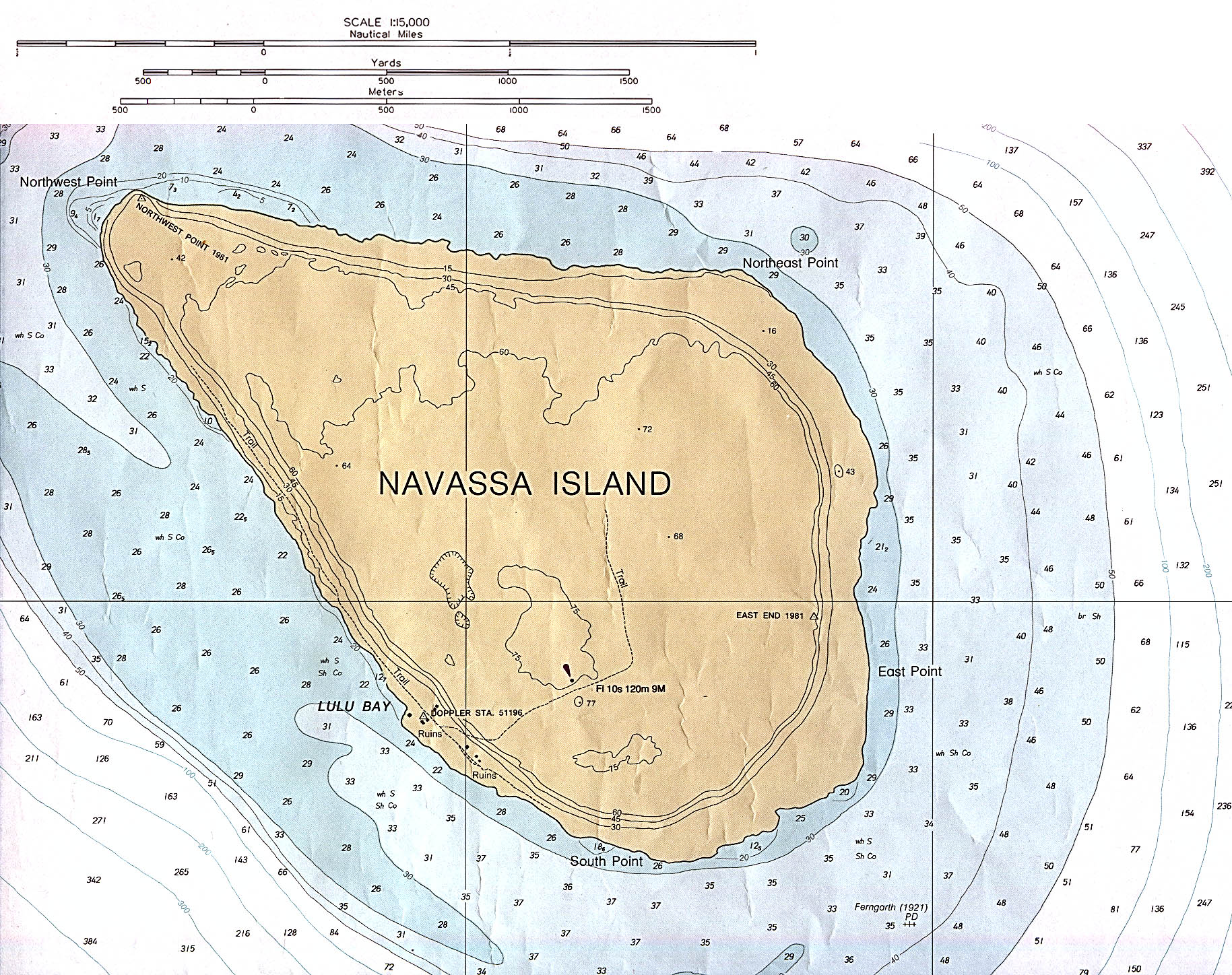
English: Navassa Island (Nautical Chart) original scale 1:15,000 Defense Mapping Agency 1982, revised 1991. |
| Tanggal | 1982, revised 1991 |
| Sumber | description source: http://www.lib.utexas.edu/maps/navassa_island.html |
| Pembuat | US Government - Defense Mapping Agency |
Lisensi
Karya ini berada dalam domain publik di Amerika Serikat karena ini adalah karya yang disiapkan oleh seorang petugas atau karyawan dari Pemerintah Amerika Serikat sebagai bagian dari tugas resmi orang tersebut di bawah ketentuan Judul 17, Bab 1, Bagian 105 dari Kode Amerika Serikat. Lihat Hak cipta.
Catatan: Ini hanya berlaku untuk karya-karya asli dari Pemerintah Federal dan bukan karya setiap individual negara bagian, wilayah, persemakmuran, kabupaten, kota, atau subdivisi Amerika Serikat lainnya. Templat ini juga tidak berlaku untuk desain cap prangko yang diterbitkan oleh Layanan Pos Amerika Serikat sejak tahun 1978. (Lihat § 313.6(C)(1) of Compendium of U.S. Copyright Office Practices). Ini juga tidak berlaku untuk koin AS tertentu; lihat The US Mint Terms of Use.
|
 | |
| Berkas ini telah diidentifikasi bebas dari pembatasan menurut hukum hak cipta termasuk semua hak terkait dan relevan. | ||
Riwayat berkas
Klik pada tanggal/waktu untuk melihat berkas ini pada saat tersebut.
| Tanggal/Waktu | Miniatur | Dimensi | Pengguna | Komentar | |
|---|---|---|---|---|---|
| terkini | 9 November 2012 23.49 | | 1.829 × 1.448 (751 KB) | Rd232 | Higher resolution version of file, from original PCL source |
| 16 Januari 2006 00.37 |  | 466 × 429 (16 KB) | *drew~commonswiki | *Description: Navassa Island *Source: En Wikipedia {{PD}} Category:Caribbean |
Penggunaan berkas
Tidak ada halaman yang menggunakan berkas ini.
Penggunaan berkas global
Wiki lain berikut menggunakan berkas ini:
- Penggunaan pada cs.wikipedia.org
- Penggunaan pada de.wikipedia.org
- Penggunaan pada he.wikipedia.org
- Penggunaan pada jv.wikipedia.org
- Penggunaan pada ms.wikipedia.org