Berkas:Cleomenes War detail 1.svg

Ukuran pratayang PNG ini dari berkas SVG ini: 343 × 360 piksel Resolusi lainnya: 229 × 240 piksel | 457 × 480 piksel | 732 × 768 piksel | 976 × 1.024 piksel | 1.951 × 2.048 piksel.
Ukuran asli (Berkas SVG, secara nominal 343 × 360 piksel, besar berkas: 931 KB)
Ringkasan
| Deskripsi |
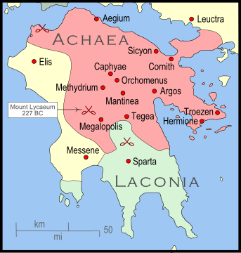
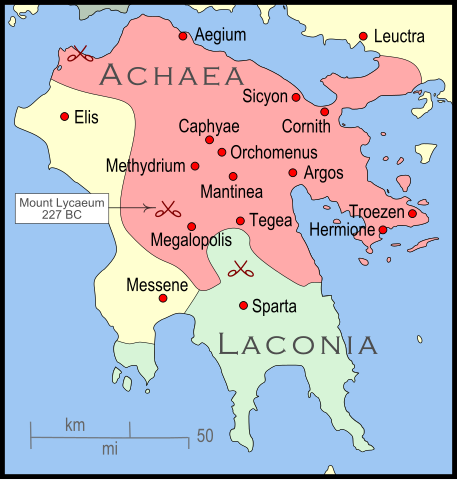
English: The Peleponnese (southernmost Greece) showing the larger powers and leagues at the time of the Cleomenean War (ca. 227 BC). The area in red shows the Achaean League. |
| Tanggal | |
| Sumber | Karya sendiri |
| Pembuat | MapMaster |
| Versi lainnya |
[]
|


References
The map itself was built using a section of File:Greece map blank.svg. Towns were placed using geographic coordinates. There is some question where the ancient city of Messene was located. Maps (see "Greece under Theban Headship") place it well inland while the modern day Messene is close to the coast.
The borders of the various political entities were taken from several sources:
- Chamoux, François (2002) Hellenistic civilization, Wiley-Blackwell, ISBN 9780631222422, p. 206, for the Achaean League.
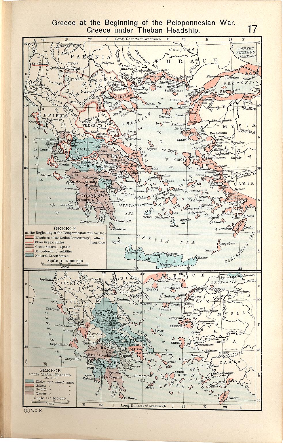
- Shepherd, William (1911) "Greece under Theban Headship", Historical Atlas, Henry Holt and Company. p. 17, was used as the primary reference for the Spartan borders. When there was a conflict with the Chamoux map, I used the Chamoux map.
Any additional information on borders and areas under control would be very welcome.
Similar maps

Lisensi
Saya, pemilik hak cipta dari karya ini, dengan ini menerbitkan berkas ini di bawah ketentuan berikut:
Berkas on ipartandoan sian on Creative Commons Attribution-Share Alike 3.0 Unported partadoan.
- Anda diizinkan:
- untuk berbagi – untuk menyalin, mendistribusikan dan memindahkan karya ini
- untuk menggubah – untuk mengadaptasi karya ini
- Berdasarkan ketentuan berikut:
- atribusi – Anda harus mencantumkan atribusi yang sesuai, memberikan pranala ke lisensi, dan memberi tahu bila ada perubahan. Anda dapat melakukannya melalui cara yang Anda inginkan, namun tidak menyatakan bahwa pemberi lisensi mendukung Anda atau penggunaan Anda.
- berbagi serupa – Apabila Anda menggubah, mengubah, atau membuat turunan dari materi ini, Anda harus menyebarluaskan kontribusi Anda di bawah lisensi yang sama seperti lisensi pada materi asli.
Riwayat berkas
Klik pada tanggal/waktu untuk melihat berkas ini pada saat tersebut.
| Tanggal/Waktu | Miniatur | Dimensi | Pengguna | Komentar | |
|---|---|---|---|---|---|
| terkini | 12 Januari 2010 04.35 | | 343 × 360 (931 KB) | MapMaster | Added a few more cities and some clean-up |
| 11 Januari 2010 05.46 |  | 343 × 360 (911 KB) | MapMaster | Changed town names to paths to properly render them | |
| 11 Januari 2010 05.38 |  | 343 × 360 (825 KB) | MapMaster | {{Information |Description={{en|1=The Peleponnese (southernmost Greece) showing the larger powers and leagues at the time of the Cleomenean War (ca. 227 BC). The area in red shows the Achaean League.}} |Source={{own}} |Author=MapMaster |
Penggunaan berkas
Halaman berikut menggunakan berkas ini:
Penggunaan berkas global
Wiki lain berikut menggunakan berkas ini:
- Penggunaan pada bg.wikipedia.org
- Penggunaan pada en.wikipedia.org
- Penggunaan pada fr.wikipedia.org
- Penggunaan pada ja.wikipedia.org
- Penggunaan pada nl.wikipedia.org
- Penggunaan pada vi.wikipedia.org