Berkas:Approximate extension of Alodia based on accounts of Ibn Hawqal.png

Ukuran pratayang ini: 800 × 581 piksel. Resolusi lainnya: 320 × 232 piksel | 640 × 464 piksel | 813 × 590 piksel.
Ukuran asli (813 × 590 piksel, ukuran berkas: 106 KB, tipe MIME: image/png)
Ringkasan
| Deskripsi |
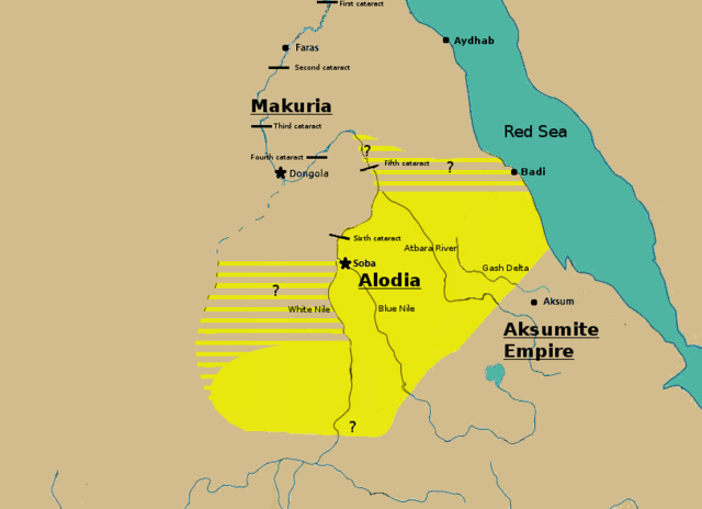
English: Initially based on map IX from the book "The Kingdom of Alwa" (see the first four versions of the map to see the faithful copy).[1] The original map had several problems, so I decided to modify it. 1) Zarroug had Alodia extend as far west as Darfur. However, there is still virtually no archaeological evidence supporting this assumption.[2] 2) The exact nothern border is still desputed; it is generally placed between Abu Hamad and the confluence of the Nile and the Atbara.[3] 3) Zarroug shows all regions west of the Nile as part of Alodia. However, the traveller Ibn Hawqal explicitly stated that parts of the region west of the White Nile were part of Makuria. The Nuba mountains were probably part of Alodia, hence I included stripes and a question mark for the area between the confluence of the two Niles and the Nuba mountains.[4] 4) There is little evidence that the Bayuda desert (between ed Debba and Omdurman) was part of either Makuria or Alodia.[5]
|
| Tanggal | |
| Sumber | Karya sendiri |
| Pembuat | LeGabrie |
Lisensi
Saya, pemilik hak cipta dari karya ini, dengan ini menerbitkan berkas ini di bawah ketentuan berikut:
Berkas ini dilisensikan di bawah lisensi Creative Commons Atribusi-Berbagi Serupa 4.0 Internasional.
- Anda diizinkan:
- untuk berbagi – untuk menyalin, mendistribusikan dan memindahkan karya ini
- untuk menggubah – untuk mengadaptasi karya ini
- Berdasarkan ketentuan berikut:
- atribusi – Anda harus mencantumkan atribusi yang sesuai, memberikan pranala ke lisensi, dan memberi tahu bila ada perubahan. Anda dapat melakukannya melalui cara yang Anda inginkan, namun tidak menyatakan bahwa pemberi lisensi mendukung Anda atau penggunaan Anda.
- berbagi serupa – Apabila Anda menggubah, mengubah, atau membuat turunan dari materi ini, Anda harus menyebarluaskan kontribusi Anda di bawah lisensi yang sama seperti lisensi pada materi asli.
Riwayat berkas
Klik pada tanggal/waktu untuk melihat berkas ini pada saat tersebut.
| Tanggal/Waktu | Miniatur | Dimensi | Pengguna | Komentar | |
|---|---|---|---|---|---|
| terkini | 27 November 2018 15.20 | | 813 × 590 (106 KB) | LeGabrie | Deleted stripes in Bayuda desert |
| 28 Oktober 2018 15.47 |  | 703 × 590 (114 KB) | LeGabrie | decreased width | |
| 15 Oktober 2018 12.51 |  | 813 × 590 (108 KB) | LeGabrie | Added Gash Delta | |
| 29 September 2018 11.38 |  | 813 × 590 (108 KB) | LeGabrie | Extended the beams over the entire Bayuda | |
| 4 September 2018 12.12 |  | 813 × 590 (111 KB) | LeGabrie | added question mark | |
| 4 September 2018 11.59 |  | 813 × 590 (108 KB) | LeGabrie | Cut the beams in Darfur | |
| 1 September 2018 00.55 |  | 813 × 590 (114 KB) | LeGabrie | Increased script size | |
| 1 September 2018 00.51 |  | 813 × 590 (114 KB) | LeGabrie | small fix | |
| 1 September 2018 00.49 |  | 813 × 590 (114 KB) | LeGabrie | Made it prettier | |
| 1 Februari 2018 21.14 |  | 813 × 590 (155 KB) | LeGabrie | Added white beams and question marks to highlight the uncertainties of Zarroug's map. These uncertainties are: The extension into Darfur,the question of ownership of northern Kordofan and the beginning of Al-Abwab. The concrete amount of desert aside o... |
Penggunaan berkas
Halaman berikut menggunakan berkas ini:
Penggunaan berkas global
Wiki lain berikut menggunakan berkas ini:
- Penggunaan pada ar.wikipedia.org
- Penggunaan pada arz.wikipedia.org
- Penggunaan pada azb.wikipedia.org
- Penggunaan pada cs.wikipedia.org
- Penggunaan pada de.wikipedia.org
- Penggunaan pada en.wikipedia.org
- Penggunaan pada es.wikipedia.org
- Penggunaan pada fa.wikipedia.org
- Penggunaan pada fi.wikipedia.org
- Penggunaan pada fr.wikipedia.org
- Penggunaan pada ms.wikipedia.org
- Penggunaan pada nl.wikipedia.org
- Penggunaan pada pt.wikipedia.org
- Penggunaan pada ru.wikipedia.org
- Penggunaan pada sl.wikipedia.org
- Penggunaan pada sr.wikipedia.org
- Penggunaan pada sv.wikipedia.org
- Penggunaan pada ta.wikipedia.org
- Penggunaan pada th.wikipedia.org
- Penggunaan pada tl.wikipedia.org
- Penggunaan pada uk.wikipedia.org
- Penggunaan pada vi.wikipedia.org
- Penggunaan pada zh.wikipedia.org