Berkas:2010 Eruption at Mount Merapi, Indonesia (ASTER).jpg
Ukuran pratayang ini: 397 × 600 piksel. Resolusi lainnya: 159 × 240 piksel | 318 × 480 piksel | 508 × 768 piksel | 678 × 1.024 piksel | 1.558 × 2.353 piksel.
Ukuran asli (1.558 × 2.353 piksel, ukuran berkas: 609 KB, tipe MIME: image/jpeg)
.jpg)
Ringkasan
| Deskripsi |
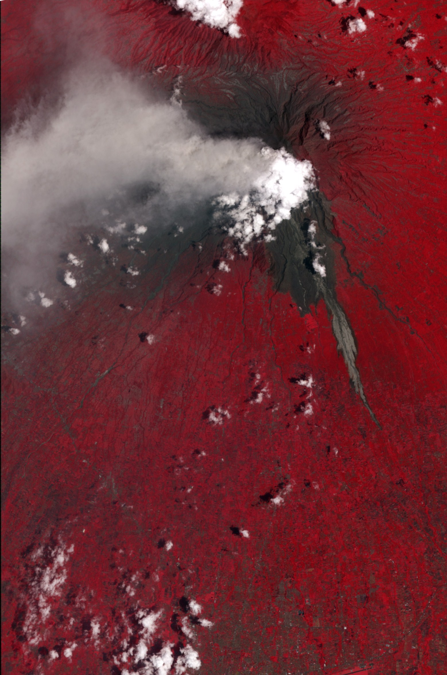
English: This false-color satellite image shows evidence of a large pyroclastic flow along the Gendol River south of Mount Merapi. Light gray volcanic deposits (either from pyroclastic flows or lahars) fill the course of the Gendol. Just north of the Merapi Golf Course (light red feature) is a much wider area where a pyroclastic flow spread across the landscape, causing almost total devastation. Within this dark gray area, most of the trees were knocked down and the ground was coated by ash and rock. The flow deposits are largely surrounded by healthy vegetation, colored bright red. A light gray ash plume extends the west of the volcano, guided by the prevailing winds. Near the plume, heavy ash-fall has coated the fields and forests, coloring them dull red to gray. |
| Tanggal | |
| Sumber | NASA Earth Observatory |
| Pembuat | NASA/GSFC/METI/ERSDAC/JAROS |
Image captured by the ASTER instrument on NASA's Terra satellite.
Lisensi
| Berkas ini berada dalam domain publik di Amerika Serikat karena semata-mata diciptakan oleh NASA. Kebijakan hak cipta NASA menyatakan bahwa "materi NASA tidak dilindungi oleh hak cipta kecuali dicatat". (Lihat Template:PD-USGov, Halaman kebijakan hak cipta NASA atau JPL Image Use Policy.) | ||
 |
Peringatan:
|
| Annotations | This image is annotated: View the annotations at Commons |
Riwayat berkas
Klik pada tanggal/waktu untuk melihat berkas ini pada saat tersebut.
| Tanggal/Waktu | Miniatur | Dimensi | Pengguna | Komentar | |
|---|---|---|---|---|---|
| terkini | 17 November 2010 11.29 | | 1.558 × 2.353 (609 KB) | Originalwana | {{Information |Description={{en|1=This false-colour satellite image shows evidence of a large pyroclastic flow along the Gendol River south of Mount Merapi. Light gray volcanic deposits (either from pyroclastic flows or lahars) fill the course of |
Penggunaan berkas
2 halaman berikut menggunakan berkas ini:
Penggunaan berkas global
Wiki lain berikut menggunakan berkas ini:
- Penggunaan pada en.wikipedia.org
- Penggunaan pada fa.wikipedia.org
- Penggunaan pada www.wikidata.org
.jpg)